2022 Drone Buying Guide

Drones are transforming construction workflows throughout the built world. The real-time insights provided by aerial technology offer significant advantage when it comes to completing projects on time and under budget.

For the third year running, we’ve compiled a buying guide of the best drones for critical infrastructure providers.

Our analysis reflects the ever-changing landscape of aerial technology, and even includes an overview of drone insurance policies and providers.

Whether just getting started or updating an existing fleet, our guide offers straightforward advice for buying your first drone, a list of common mistakes to avoid, and in-depth reviews of 2022’s top products.

2022's Best Drones for Construction

Overall performance

DJI Phantom 4 V2.0
dji phantom 4 V2.0
Learn More

Ease-of-use

DJI Mavic 2 Pro
dji mavic 2 pro
Learn More

Portability & storage

DJI Mavic Air 2
The Mavic Air 2 drone
Learn More

Durability

ZeroZero V-Cptr Falcon
zerozero cool drone
Learn More

Video production

DJI Inspire 2
dji inspire 2
Learn More

Enterprise

DJI Matrice 600 Pro
DJI Matrice 600 Pro
Learn More

If you want to go straight to the full reviews for each drone, jump ahead to the section on top drones for the construction industry.

You might be tempted to dive right into comparing specific drones, but try to resist. First, you should determine your needs and choose the appropriate software. We'll say it again - pick your software before even looking at hardware.

Software is how you'll manage your drone data, which is the most valuable aspect of drone ownership. More than that, the software you use will affect your drone choice, so you'll need to have it picked out before you begin drone shopping.

Before diving into software, first decide what you need the drone for and how you intend to use your data.

Determine Your Needs

The first step to purchasing your drone is determining how you’re going to use it. To get a better understanding of what you want to do with your drone, ask yourself the following questions:

For what purpose will you use your data?

Marketing:

4k video and high-resolution photos

Inspection:

20fps mechanical shutter and high-resolution video transmission to remote controller

Survey:

GPS-enabled project maps with elevation data

Vertical Scan:

LIDAR color camera & 3D modeling software

Why it matters

Answering this question determines how you’re going to get value from your drone and what kind of software you’ll need to purchase. Having a plan for data use will not only help you find the right drone, but also save time and money when operations are underway.

How often will you be flying?

Daily/Weekly:

A professional level drone (all our top picks fit the bill), built to withstand the wear and tear of a construction site, backed by comprehensive insurance

Quarterly/Annually:

“On-demand” insurance coverage and a drone that scores high on ease-of-use

Why it matters

Flight frequency affects both hardware and insurance plan you'll need. If you plan to fly daily (or even weekly), consider ease-of-use and make sure you have the right coverage option.

What kind of videos and images do you need?

Cinematic Video/Images:

3-axis gimbal, panoramic wide shot camera, selfie flight modes

Thermal, LIDAR, Vertical Scans:

modular payload, multi-rotor construction

Visual Inspections:

3-axis gimbal, collision detection system

Why it matters

Your drone can do a lot more than just take site surveys. They can also take gorgeous videos for marketing purposes and stakeholder updates.

Considering your imaging needs further clarifies your hardware requirements. Different drones excel at collecting different kinds of visual data, so be sure you have the right functionality.

What climate will you be flying in?

Rain, Wind, Extreme Temperatures:

The best camera your budget allows and a flight time > 27 minutes. Stabilizing your drone in strong winds reduces battery, so a longer flight time will keep you operating in rough conditions.

Temperate:

Portable, light-weight options might make the most financial sense when flying in clear conditions.

Why it matters

Wind and rain are your two biggest enemies when trying to fly, but not for the reasons you might think. Most modern drones can remain stable in strong wind gusts, but low light and standing water can make it difficult to capture and stitch clear, accurate images.

Choose Your Software

Putting your data to work is all about choosing the right software.

After all, a gorgeous site survey is only useful if you can edit and share the information. The same is true of cinematic videos shot in 4k. Yet, these two cases require different software. So what’s the best software for you?

There are several types of drone software, each involved in a different process. We provide breakdowns of the use cases below.

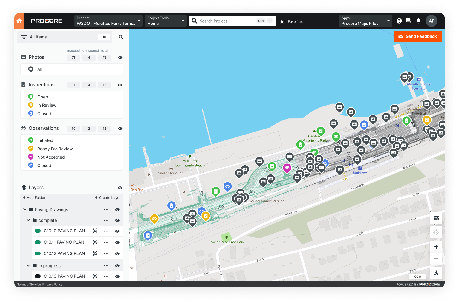
Layers on a base map

Data management: download, stitch, and utilize

Purpose

Data management is where the real value of your drone will be realized. It should be easy to visualize, analyze, and share information from a single platform. Our software does just that. Of course, we're a little biased, but we do recommend you explore your options, as this is a critical choice.

Features

-Download and stitch aerial images into a base map

-Measurement tools for analyzing your geospatial data

-Collaborative platform for sharing insights and files

Providers

Kespry

DroneDeploy

ArcGIS

Points on a map

Mission planning: plot, upload, and fly

Purpose

Operating your drone on a computer controlled, pre-programmed flight path is the easiest way to achieve consistent quality. Many drones offer on-deck flight programming, but these options allow even more control.

Features

-Waypoint missions and flight logging

-In-flight checks

-VR integration or 4K transmission

Providers

Litchi

DroneDeploy

Pix4Dcapture

A drone surveying a construction site

Airspace: situational awareness

Purpose

Airspace apps help you monitor weather, no-fly zones, and flight logs. They are most helpful for flying in frequently changing conditions and locations, or those who must fly close to airports.

Features

-Instant notifications

-Flight integration & FAA maps

-Collaborative platform for sharing insights and files

Providers

Airmap

Measure

Skyways

a drone mapping assets on a map

3D mapping: modeling on any scale

Purpose

3D Models provide an accurate way to measure almost anything. With drones, scaling large objects in three-dimensions has never been easier.

Features

-Automated structural inspections

-Distance measurement tools

-Collaborative platform for sharing insights and files

Providers

PRENAV

Kespry

Agisoft

Choose Your Drone!

Once you've picked your software, it's time to move onto hardware.

Drones are loaded with gadgets and there are several important factors to consider when choosing what's right for you. You might be asking: What's the best drone camera? Is collision detection worth it?

We'll answer those questions and more below, covering cameras, collision detection, ease-of-use, and overall stability.

Getting the right camera

Why it matters

Camera quality and gimbal mount are defining factors of drone performance. If precise imaging or aerial cinematics are your priorities, don’t skip on a 3-axis gimbal. A higher quality camera with more stability will pay-off.

Drones have two types of payload: modular and fixed. Modular drones have interchangeable parts, meaning you can swap the camera and rotor blades. While this is a big advantage in specific cases, fixed payloads are simpler, cheaper, and require less specialization.

Look for

Lense & Sensor Quality:

We recommend a sensor no smaller than 23.7x15.6mm. Top tier drones often feature a 1-inch sensor.

Gimbal Mount:

Video production? 3D modeling? Detailed inspections? Go with a 3-axis gimbal.

Shutter Speed:

Shutter speed will determine the clarity of images taken in mid-flight. For the highest resolution, you’ll need 1/8000s.

Collision detection & communication loss

Why it matters

Communication loss is inevitable when remote controlling a drone, making recovery flight mode and collision detection invaluable.

Cutting edge radio cameras, like on the Zero Zero V-Coptr Falcon, maintain 360 degree obstacle avoidance anytime the drone is airborne.

Look for

Radio Cameras:

Excellent for obstacle avoidance, radio cameras are the most reliable systems on today’s market.

Communication loss override:

When the signal between controller and drone is lost, you’ll want a flight mode that automatically finds its way to safety without losing collision detection.

Ease of use

Why it matters

Is it easy to get your drone out of the box and into the air? How easily you can get your drone flying will make a difference in how quickly you can capture data, and how much time your employees spend learning to fly.

This is one major advantage of having a fixed payload. You won't need equipment lists or tooling specifications, making it easier to get to work.

Look for

GPS calibration

Drones require calibration to maintain accurate flight paths. Choosing a drone with clear instructions will prevent unexpected delays and bad data collection.

Flight modes:

Drones with preset flight modes, accessible from a touch screen controller, will flatten the learning curve for new pilots.

Durability & stability

Why it matters

Flying a construction drone means you don’t have much choice about the timing and conditions in which you fly. You have to get your images and you have to get them regularly. Your drone has to be able to stand up to adverse weather and the occasional collision.

Look for

Wind resistance:

If you’re consistently flying in stormy weather, we recommend a drone with a wind speed resistance of 20 MPH.

Battery life / Flight time:

Stabilizing your drone in strong winds reduces battery, so a flight time > 27 mins will keep you operating in rough conditions.

Drone Insurance Policies & Providers

Like any other vehicle, you'll want insurance when flying drones. There are three kinds of coverage: Liability, Hull, and Payload Insurance.

For commercial needs, you'll want a policy that includes all three. Because you need protection against theft, we recommend annual plans over "on-demand" coverage that charges per flight hour. Now how much should you spend, and what limits do you need?

Types of drone insurance

Liability

Insures against damage to power lines, structures, and people.
Limit: $1,000,000+
Term: Annual
Rate: $500 - $750

Hull & Payload

Covers your hardware & payload against accidental damages.
Limit: $5,000
Term: Annual
Rate: $85

"On-Demand"

Pay-per-flight coverage, perfect for one-time operations.
Limit: $1,000,000+
Term: Hourly
Rate: $7

Providers

Skywatch A.I

DroneInsurance.com

Thimble (formerly Verifly)

The Best Drones By Price

Cutting edge drone technology is more affordable than ever. With a price spectrum ranging from $40 - $40,000, it's useful to have an overview of market prices.

$500 and Under

DJI Mavic Mini

dji phantom 4 V2.0

Pros

  • Ultralight
  • 4K Video
  • 3-Axis Gimbal
  • Foldable Body

Cons

  • Non-functional in high winds
  • Low altitudes (under 40 ft.) only
  • Short transmission range

$500 - $1,000

ZeroZero V Coptr Falcon

zerozero V-Cptr Falcon futuristic drone

Pros

  • 50-min flight
  • State-of-the-art flight modes
  • 7 km transmission range
  • Excellent imaging specs

Cons

  • Smaller camera sensor
  • Non-mechanical shutter

$1,500 - $3,000

DJI Phantom 4 V2.0

dji phantom 4 V2.0

Pros

  • Top tier camera specs and imaging
  • 5-Direction obstacle sensing
  • Long range transmissions

Cons

  • Larger, less portable body
  • Short transmission range

Enterprise: $3,000 - $5,000

DJI Inspire 2

DJI Inspire 2 drone with camera

Pros

  • Top tier camera specs and imaging
  • Modular payload
  • High wind resistance

Cons

  • Larger, less portable body
  • Steeper learning curve

Industrial: $5,000+

DJI Matrice 600 Pro

DJI Matrice 600 Pro

Pros

  • Top tier camera specs and imaging
  • Modular payload
  • Long range capacity

Cons

  • Requires expert operator
  • Higher insurance demands


Avoid Common Drone Buying Mistakes

There are a few cautions to keep in mind when purchasing a construction drone:

DON'T only consider buying the newest, most expensive drone.

Drones are always evolving. The latest and greatest technology will quickly come down in price. If a cheaper, older option still fits your needs, we recommend you check it out.

DON'T try and get by with a hobbyist drone.

Hobby drones may be cheaper (and fun to fly), but they are not designed to be the reliable workhorse you need. You should definitely avoid using consumer drones for professional purposes. With the portability of models like the Mavic Air 2, the advantages of hobby drones have been replaced.

DON'T spring for a fixed-wing drone.

There’s a reason most of the drones you see in use are quadcopters. Fixed-wing drones have specific scenarios where they are superior, mainly with regards to flight endurance and range. Unfortunately, these benefits are null as regulations require that you maintain visual contact with your drone (what good is a range of several miles if you can’t use it?). And, in general, fixed wing drones are more difficult to maintain, launch, and land.

DON'T buy a drone that doesn’t automatically insert geolocation data into each photo.

Geo-reffing sucks. It involves combing through thousands of photographs and matching drone GPS data to the timestamps on your individual photographs. If your drone isn’t automatically inserting geo-location data into each photo, you’re wasting time and energy.


In-Depth Drone Reviews

Best all-around drone

DJI Phantom 4 V2.0

DJI phantom 4 pro
Purchase

Manufacturer:

DJI

Weight:

1375 g/3.03 lbs

Battery Life:

~30 minutes

Price:

$1,599.00

For the third year in a row, DJI's widely acclaimed Phantom 4 tops our list of the best all-around drones. State-of-the-art imaging and intuitive flight controls make the V2.0 a do-everything powerhouse that's perfect for the toughest jobs on site.

Best drone for ease-of-use

DJI Mavic 2

DJI Mavic 2
Purchase

Manufacturer:

DJI

Weight:

907 g/~2 lbs.

Battery Life:

~30 minutes

Price:

$1,599.00

The Mavic series from DJI is the industry standard for out-of-the-box simplicity. The Mavic 2 offers outstanding performance with intuitive controls, streamlining the larger Phatom 4's features into a more user-friendly bundle. If you're buying your very first drone, this is a great option.

Best drone for portability

Mavic Air 2

The Mavic Air 2 drone
Purchase

Manufacturer:

DJI

Weight:

570 Grams/1.23 lbs

Battery Life:

~33 minutes

Price:

$799.00

The Mavic Air 2 packs a big punch for a drone so small. Weighing in at a little over 1lb, the Air 2 manages 4K Video and 33 minutes of flight time within a go-anywhere design. If you’re going to be traveling frequently with your drone, this option is a no brainer.

Best drone for durability and stability

Zero Zero V-Coptr Falcon

ZeroZero labs V-Coptr Falcon
Purchase

Manufacturer:

Zero Zero

Weight:

730 g/1.6 lbs.

Battery Life:

~50 minutes

Price:

$999.00

It's hard not to get excited about the latest offering from ZeroZero. Featuring a V-shaped, dual-rotor design, the V-Coptr Falcon is equipped with best-in-class imaging & collision detection. Boasting a 50 minute flight time and 7km transmission distance, the Falcon is built for a long day's work.

Best drone for video production

DJI Inspire 2

DJI Inspire 2 drone for movie making
Purchase
Manufacturer:

DJI

Weight:

3440 g/7.58 lbs.

Battery Life:

~25 minutes

Price:

$3,299.00

The Inspire 2 is the gold standard of video-capture drones. If you're a marketing professional looking to produce content fit for the big screen, this is your best bet. A modular payload and cinematic flight modes allow unmatched versatility in getting the right shot.

Best drone for enterprise projects

DJI Matrice 600 Pro

DJI Matrice 600 Pro
Purchase

Manufacturer:

DJI

Weight:

9.5 kg/20.9 lbs.

Battery Life:

~35 minutes

Price:

$6,599.00

Though the price tag may seem high, the Matrice 600 Pro is built for professionals, and meets broadcasting requirements. Compatible with multiple cameras, the Matrice is customizable, and ensures reliability and safety through six rotors and an intelligent six-battery system. And with an extended flight time and 5km reach, the Matrice is in a league of its own.

Let us know if you have questions!

That should cover everything you need to get started.

For more information, be sure to check out our pieces on How to Get Started with Drones in Construction and Fixing Precision in Drone Surveys.

Increase visibility with modern mapping tools

If you're interested in drones, you understand the importance of visibility - whether it's for a personal project or professional job site.

For this reason, Unearth developed OnePlace - mobile software that visualizes your work and data on a map in real-time.

With unlimited cloud storage, create multi-layered maps (satellite imagery, drone surveys, PDFs, CAD files, etc.), leverage simple drawing and measurement tools, collect information with intuitive forms, and geo-locate photos, video, and audio - on any device.

Use elevation measurements from drone data to monitor stockpiles and other site changes

Get the latest in infrastructure news. Sign up for our newsletter.