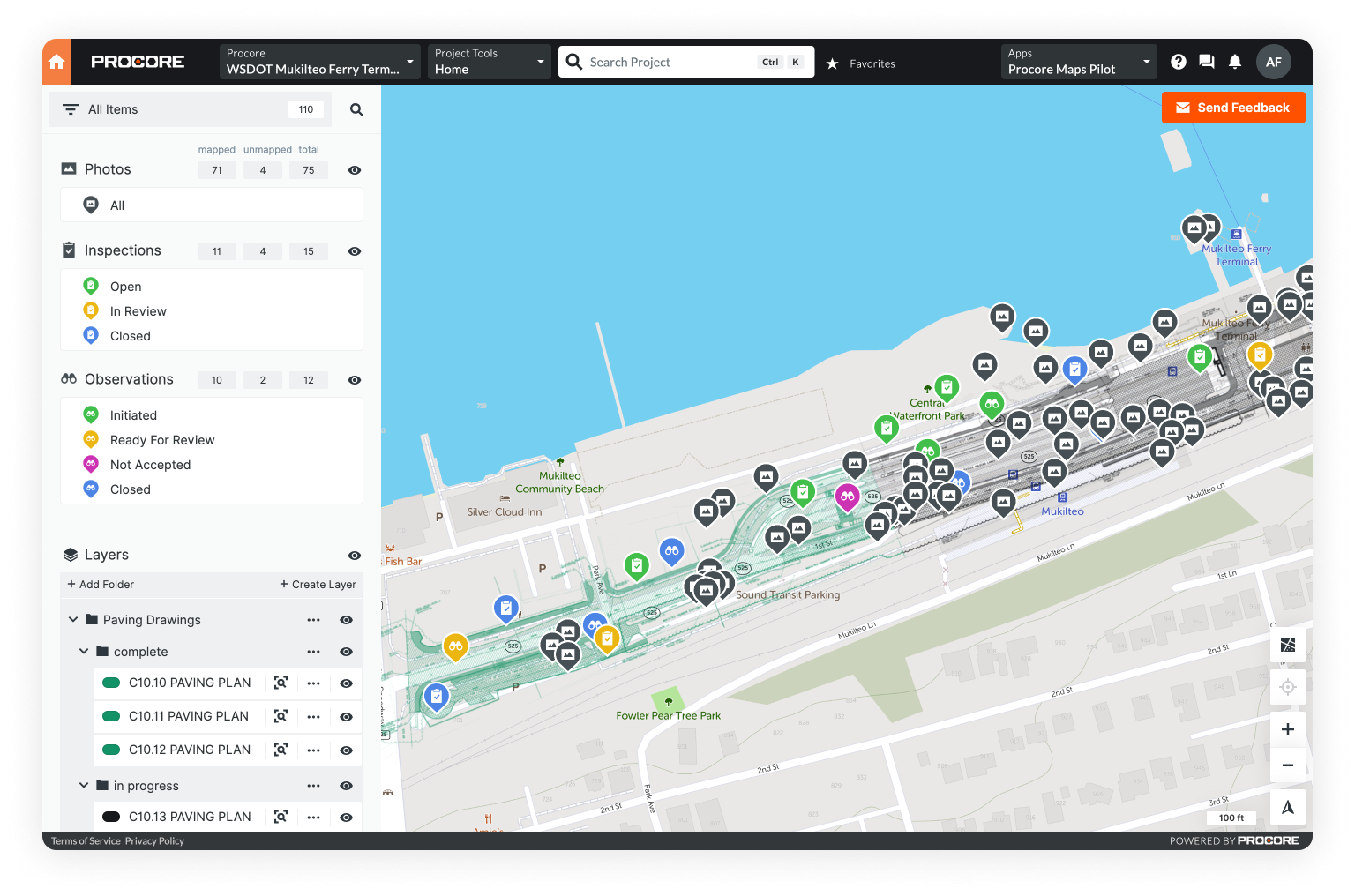
GIS boils down to the mapping of data, and it isn’t far from the technology you may already be using on your construction projects.
New to GIS? Learn the basics in Intro to GIS: How It Works and How to Get Started.
After all, the plans you regularly consult are a partial map -- just without real-world coordinates. If you're using drones, you're capturing another type of map in the aerial imagery. And for Google Earth users, mapping is already a key part of your process.
GIS takes these separate types of data and layers them on a single map for a comprehensive picture of your project.
Now more than ever, it makes sense to use location as the organizing principle for all of your project data. Teams manage historic quantities of information, and this data represents physical structures in the real world and may already include GPS coordinates.
GIS mapping is the perfect tool to manage these complex projects.
What Is GIS?
GIS stands for “geographic information system.” It’s a computer system that organizes, stores, analyzes, and maps data. You can think of GIS as the intersection of location and data.
GIS involves layering location-based data on a map; a GIS can work with any data that relate to a specific place.
In construction, this could include:
Drawings
While drawings don’t contain geographic data, they do represent built assets that occupy real-world space and can easily be mapped with GIS.
Overlaying plans on a basemap helps you see where everything is not only within the structure you’re building, but also in the context of the asset’s physical location.
Photos
Photos record conditions at actual locations on your jobsite, and when captured with mobile devices, they also contain GPS coordinates in their metadata.
With GIS, you can pin photos to the exact spot on the map where they were taken. This provides an accurate view into what’s happening – and where – on your project.
Project documents
Project documents like permits, RFIs, and inspection forms concern issues or actions carried out at specific places, which lend themselves to being mapped.
You can choose different icons to symbolize document types on your map, and you can tie the color of the icons to statuses. For instance, an inspection icon could be red when it has not yet been completed and could change to green when finished.
Assets
GIS makes it easy to draw existing infrastructure, utilities discovered in the middle of a project, or the assets you’re installing on the jobsite map.
You can use different symbols to portray these assets and include details (e.g., material type, installation date, etc.) in a linked form right in the GIS.

Redlines and as-builts
Annotation tools also enable users to record project revisions directly on geolocated drawings.
You can document project changes when they happen and where they happen, which helps ensure your as-built data is accurate and comprehensive. You’ll also be recording the location data that is so critical to owners later in the asset life cycle.
By visualizing information on a map with GIS, you’ll see the relationships that might exist between different types of data attached to the same location.
This holistic view of a project keeps construction teams better informed of progress and better positioned to make effective decisions.
Mobile GIS Is Key to Success
It’s important to note, though, that not all GIS are the same.
Legacy systems
For much of GIS’ existence, it was a desktop system that could be accessed only on the computers and local servers on which it was installed. And it required advanced training to operate, making it the domain of specialists.
GIS shifts online
But over the last decade, GIS software has evolved from legacy desktop systems to more accessible online or cloud-based products. Many GIS can now be accessed from anywhere and data can be added directly from the field.
However, this cloud-enabled access only gets you so far. A critical piece of GIS is ease of use. Most legacy GIS have migrated online or to the cloud, but they remain difficult to use without specialized training or support.

Truly accessible GIS
Enter Mobile GIS. Mobile GIS is cloud-based software built specifically to be used on mobile devices in the field with little to no training.
With Mobile GIS, it’s easy to capture, share, access, and collaborate on project data from wherever you are, so it’s a great solution for some of the challenges the construction industry faces today.
Why Construction Needs Easy-to-Use GIS
Construction has the potential to generate a lot of data. A 2018 report shows that some of the largest infrastructure projects produce 130 million emails, 55 million documents, and 12 million workflows.

That’s a lot of information to keep track of, which helps explain why 95.5% of construction and engineering data goes unused and a construction project team member can spend up to 5.5 hours per week hunting down project data.
A GIS is an ideal place for this information to be organized and accessed by stakeholders.
After all, the construction industry deals with the built world: physical structures that occupy space. And managing this data is complex.
Construction data management is challenging ...
The sheer volume of information a project can produce is overwhelming in itself, but the type, source, and storage of this information makes data management even more complicated.
Mixed datasets
Construction project information takes many forms: drawings, emails and texts, documents, photos and video, drone and satellite imagery, LiDAR surveys, 3D models, and more.
Commonly, different systems or apps are needed to view or work with these various data types.
Multiple data sources
Data also comes from many different sources.
Consider all the people that have a hand in getting a project built – office and field personnel, numerous subcontractors, vendors, owners, engineering and design firms, and regulatory bodies.

Each entity likely has their own method for sharing data. This includes paper, email, shared folders, program or project management software, and reality capture tools.
Data silos
Plus, project information is captured often with apps that don’t integrate with the rest of your tech ecosystem, stored on individual devices or computers, or shared via email and text.
Data is siloed among team members and lost in the shuffle, which causes serious headaches. Teams waste hours in unnecessary meetings, site visits, or searching to find the information they need.
… but accessible GIS can help
GIS excels at mapping mixed datasets. It can visualize your various data types as layers that can be toggled on and off or as icons you can click to open the associated photo or form. And it’s able to import a variety of file types common in the construction industry – PDFs, KML/Zs, CSVs, and photo files.
Mobile GIS enables easy collection of data in the field with smartphones and tablets, eliminating the need to use slow, error-prone, paper-based processes. When your GIS is cloud-based, this data is uploaded as soon as it’s captured – giving your team real-time access to usable project data.
5 Applications of GIS in Construction
Ultimately, GIS is used to organize construction data in one place, so users can easily visualize, access, share, and collaborate upon it.
As such, construction teams are using GIS to better manage day-to-day workflows and tasks.
Here are a few examples where GIS can help streamline processes and save crucial time and costs:
1. Progress monitoring and reporting
A GIS displays project data in an easily digestible format, rather than stuffed into file folders or confined to cells in a spreadsheet.
Detect issues early
You can more easily stay up-to-speed with where your project stands when your information is where you can see it and new information from the jobsite is shared in real time in one central place.
You can also spot potential issues earlier and take action to avoid costly rework or delays.
Easily reference your full project record
It’s not only the present conditions of your project that are useful.
A GIS puts a comprehensive record of information at your fingertips. Comparing your most recent project data against older information can provide insight into how work is progressing.
Keep owners well-informed on progress
Better organized data not only makes progress monitoring more manageable – it makes sharing that progress with owners simpler as well.
You can grant owners access to the project map to explore up-to-date data. Alternatively, project information can be filtered to include the data of interest to owners and then exported in their preferred format.
2. As-built documentation
Historically, the process of documenting as-built conditions and compiling as-built drawings involved manual transfers of revisions that were time consuming and led to inaccurate and incomplete project records.
Even with a shift to some digital processes – marking up a PDF instead of a printed plan, for example – redlines and as-built data can fall through the cracks if teams lack easy means to document changes from the site or share updated information in real time.

Create your as-built as you go
Using cloud-based GIS can change the as-built game.
You can document changes to plans in the field as they happen – workers can mark up plans on their mobile devices and capture images of the most up-to-date work. All of this as-built data is geolocated, displayed on the project map, and shared in real time with stakeholders, so everyone always has the most current project information.
Deliver a high-quality as-built at project close
Because you’re documenting changes as they occur, your as-built is complete and ready to pass on to the owner when construction is finished. Many owners recognize the value of location data for their ongoing operations and maintenance, and may already use GIS as a system of record for their assets. They'll appreciate a digital as-built in GIS format, where everything is geo-referenced and searchable by location on an easy-to-understand map.
3. Site inspection management
With Mobile GIS, you can easily capture inspection information in the field.
You can fill out customized digital forms from a smartphone or tablet – and avoid the time-consuming manual transfer of data and risk of errors that come with paper-based processes. Your project team can then access the data from completed inspections from the field or office as soon as it’s collected.
Keep an organized inspection record
Notably, your inspection form will be automatically geolocated and timestamped, making it simple to retrieve later by location or date.
Get a quick view of inspection status
An icon representing the inspection data will also appear on a map of your project, so you can see at a glance where on the jobsite inspections have been scheduled and/or carried out.
4. Navigation of jobsites
A GIS’s project map is also useful for navigating construction sites. This is particularly true for large-scale infrastructure that may cover many miles of ground.
Efficiently get people and materials where they need to go
With Mobile GIS, a construction worker arriving on site can pull up their project map on their smartphone and check not only what their assigned task for the day is, but also clearly see on the map where their work needs to be done – and how to get to that spot.
Likewise, a project map can enable easy coordination for material deliveries. Just provide the delivery person with view-only access to the project map, and they will be able to navigate to the right place on your jobsite.
5. Photo documentation
A photo is worth a thousand words, as they say, and the construction industry is embracing the ability of photos, video, and drone and satellite imagery to quickly and accurately document jobsites.

In fact, a 2021 report revealed that the No. 2 reason mobile devices are used in the field is to take photos and video.
But this valuable data can quickly get lost in the shuffle when people share it via texts or emails or upload it to an unorganized folder.
Instantly organize jobsite photos by location
Photos captured with mobile devices and saved in a GIS, on the other hand, will be timestamped and geolocated automatically.
Images get pinned to your project map at the exact spot they were taken. Stakeholders can see the photos in real time and in their real-world context.
Save time searching for photos
Team members in the office or in the field can quickly and easily search project photos by highlighting parts of the map and seeing the images associated with the selected areas.
Specifying a date range can narrow search results even further. With photos organized in a GIS, you can find the imagery you need in moments, rather than spending precious time on a frustrating search of emails, texts, or file folders.
Benefits of Using Accessible GIS in Construction
Importing your data into an accessible GIS – and therefore onto a digital map – gets it out of extensive folder structures or spreadsheets, and puts it all in clear view for your entire team.
This accessibility is an immediate benefit of using GIS in construction, and it leads to several key advantages.
Easy field data collection and collaboration
Any new project data generated in the office or captured in the field with mobile devices – redlines, digital forms, photos, notes – are automatically geolocated and organized in one place that everyone on the team can easily access in real time.
Bypassing manual transfers of data means this project information is more accurate as well.
Enhanced project visibility
A continuous stream of high-quality data leads to enhanced project visibility, streamlined communication, and improved decision-making.
When everyone is working from the same up-to-date project information, they can spot potential issues and quickly collaborate and decide on solutions. This helps avoid costly rework, disputes, or delays.

High-quality project turnover – and impressed clients
By compiling accurate and timely as-built documentation during construction, you’ll have a well-organized deliverable to hand off to the asset owner at project close.
With location data, this digital as-built will go far in supporting the owner’s ongoing operations and maintenance efforts – and can set you apart from the competition.
Fewer headaches, delays, and costs
Everything we’ve discussed so far adds up to time and cost savings, as well as a smooth project.
A recent study surveying contractors with experience using GIS showed that 40% of them are employing GIS on more than half of their projects. They report improved productivity, increased client satisfaction, and better coordination on jobsites.
The study’s findings suggest that GIS use in the industry will only increase from here.
Conclusion: How to get started with easy-to-use GIS
At Unearth, we’ve built an intuitive Mobile GIS called OnePlace that makes mapping your project data simple.

OnePlace saves you time by simplifying the search for data and visualizing all your information on an easy-to-understand map. Update the map in real time and keep colleagues in the office, trailer, and field up to speed on jobsite status.