Intro to GIS: How It Works and How to Get Started

Chances are you’ve heard of GIS. But given its history as a technology reserved for experts, it’s also likely that what GIS is and what it does remains a bit of a mystery.

Simply put, GIS involves layering location-based data on a map. Visualizing data in this way improves our decision making and understanding of the world around us.

GIS has traditionally been the domain of the specially trained few, but the last decade saw the emergence of modern GIS software that is much more accessible – from both useability and cost perspectives.

GIS is now a feasible option for anyone to manage data, so it’s worth learning more about how it works, where it’s used, and how you can harness its benefits.

GIS Basics: What It Is and How It Works

GIS is a broad category and there’s a lot to learn – people get degrees and build careers in GIS.

However, the fundamentals are easy enough to grasp. And thanks to modern GIS and mobile technology, implementation is easier than ever.

Let’s dive in by answering the big question: What is GIS?

GIS defined

GIS stands for “geographic information system.” It’s a computer system that organizes, stores, analyzes, and maps data. In this way, GIS is the intersection of location and data.

How it works

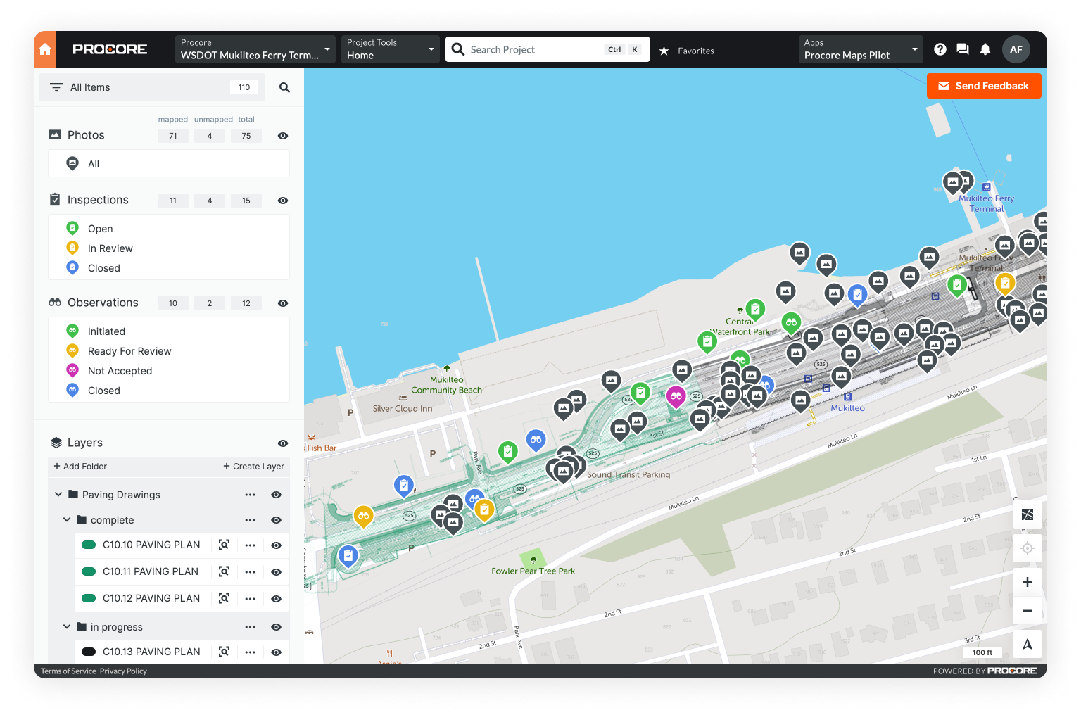
With GIS, different sets of location-based data are added to a map as separate layers.

This visual representation makes it possible to understand data in context and see the relationships that might exist between different types of data attached to the same location. 

Data mapped in a Mobile GIS.
A plan layered on a map in Unearth's OnePlace Mobile GIS software.

Check out our five-part guide to GIS for an even more comprehensive overview.

A brief history of GIS

You can see how a map can get pretty complex the more data you add.

Traditional 2D paper maps can only include so much information before they become too complicated to be useful. 

Thankfully, GIS addresses this limitation.

GIS was developed beginning in the 1960s to harness the power of computers to store and process large amounts of geographically referenced data.

In 1969, the Environmental Systems Research Institute – ESRI – was founded. ESRI developed many of the spatial analysis and GIS mapping methods in use today. And in 1981, it released the first commercial GIS software. 

The integral role ESRI played in the growth of GIS and the continued market dominance of its software (now known as ArcGIS) explains why “ESRI” and “GIS” are synonymous for many people.

GIS today: more accessible and more mobile

Legacy GIS platforms, like ESRI, offer powerful features. But they generally also require a degree or specialized training to operate. And though these legacy systems have migrated to the cloud in recent years, they traditionally stored data only on local servers.

As a result of these factors, GIS has been the domain of specialists working in offices on desktop computers. And it has earned a reputation for being far too complex for someone without high-level training and education to understand, let alone use.

But over the last few years, modern software options have made GIS accessible to people without advanced degrees or experience. And while these platforms are less robust than their legacy counterparts, they tend to be cloud-based and mobile-friendly.

Conceptual art representing access to GIS via a smartphone.

This means users can employ GIS in the field to collect and share data from wherever they are.

Uses of GIS

The emergence of more user- and field-friendly GIS software has meant that more people than ever are using GIS. But what exactly are they using GIS to do?

1. Mapping

The most common use for GIS is mapping – giving location-based data visual representation. These maps form the basis for the other GIS uses explored below.

Some traditional GIS map types include:

  • Category maps, which visualize segments of data as they relate to specific portions of the map. Examples of category maps are sales territories (who covers which area) and favorite sport by country.
A category map created with GIS.
An example of a category map.

  • Quantity maps, which chart density across geographical or political regions with well-defined – if somewhat arbitrary – boundaries, like states or counties. Population density maps are a common example of quantity maps.
  • Heat maps, which – like quantity maps – illustrate density, but do so over a standardized grid. For instance, a heat map would be used to visualize weather patterns, which occur independently of geopolitical boundaries.

Advances in GIS accessibility, mobility, and ease of use have expanded the range of GIS mapping that’s possible today. With modern GIS platforms, users are creating:

  • Inspection maps that not only show the status of inspections at specific locations in real time, but also incorporate relevant notes, photos, and videos with inspection data.
  • Asset maps that keep track of data related to the operation and maintenance of assets – such as land, buildings, infrastructure, and more – over their lifespan.
  • Project maps that are useful in tracking large-scale, built-world projects. Tasks and comments can be added to the locations on the map that they concern, giving project managers a real-time view of where work stands.

Let’s explore these in a little more detail.

Understand mapping basics and unpack GIS map types in our overview of GIS Mapping.

2. Data management

GIS excels when it comes to organizing, analyzing, and sharing geographically referenced data. 

Spreadsheets, photos and video, satellite and aerial imagery, remote sensor data, construction drawings or plans, and more can all be managed with GIS.

Collecting and storing data in a GIS also means you can create a rich data record associated with a specific location over time – which provides a convenient reference resource as well as a basis for predictive data modeling.

3. Asset management

Built assets occupy physical space and have lots of data associated with them, such as blueprints, maintenance and inspection records, and performance metrics.

GIS can keep this data organized. As a result, teams use GIS to inform decision-making, maintain up-to-date asset inventories, and devise preventative maintenance schedules.

An asset map used for asset management, created with a Mobile GIS.
Assets mapped in OnePlace, a Mobile GIS.

4. Task management

Task management involves keeping track of assigned actions that are related to a specific place.

In construction, for instance, this could refer to drywall installation in one structure on a large jobsite. Information related to who should perform that work, what materials to use, and when the job is complete can all be associated with a place on the map.   

5. Change detection

GIS makes it possible to track change across large areas over extended periods of time visually. For instance, workers can spot changes quickly by layering aerial surveys or comparing geolocated photos taken throughout the month.

GIS data: what can you put on your map?

Mapping is the most common use of GIS. But without layers of data, a GIS map will be little more than a simple reference map.

So what kinds of information can you map?

GIS can map spreadsheets, forms, PDFs, photos and video, drone and satellite imagery, construction drawings, topographic maps, LiDAR data, and so much more – including, of course, specialized GIS file types.

Two main GIS data types

The main spatial data types are vector and raster.

Vector data renders imagery using points, lines, and polygons. They can scale infinitely without the image becoming distorted because they are graphical representations of an image.

Vector points illustrate features too small to be drawn at scale. For instance, a city will be represented by a point on a map of the United States. Vector lines represent linear features like rivers or roads, and polygons represent features with distinct boundaries, like a state or a lake.

Raster data provides a more literal representation of images. It’s pixel or grid based, and can’t scale infinitely like vector data – it will distort or become pixelated. In GIS mapping, raster data generally represents surfaces. Digital photos are an example of raster data.

Common GIS file types

Under the vector and raster umbrellas are numerous GIS file types – more than 60. Six of the most common are:

  • Shapefiles (.SHP)
  • Geographic Javascript Java Notation (.GEOJSON, .JSON)
  • GeoTIFF (.TIF, .TIFF, .OVR)
  • ESRI File Geodatabase (.GDB)
  • Keyhole Markup Language (.KML, or .KMZ for KML-Zipped)
  • Comma Separated Value File (.CSV)
Take a deeper dive into GIS file formats in Unearth’s overview of GIS data.

Learning GIS

These days, GIS is available to anyone – it’s no longer only for specialists. You can be well on your way to mapping data and gleaning new insights from your information with an app, a smartphone, and a small learning curve.

That said, capitalizing on more advanced GIS capabilities (geoscientific research, complex spatial analysis, and 3D rendering, for example) does require more specialized knowledge.

There are a few pathways to learning GIS, and your desired level of proficiency and ambitions will determine the best route for you.

For those looking for a career in GIS, a degree is essentially required – you’ll want to start searching GIS educational offerings at colleges. Professionals who are already working in the industry can learn specialized skills through GIS certification.

A person learning GIS through an online course.

Of course, resources to learn GIS on your own are also available. Online tutorials, lectures, courses, and textbooks – some free, some paid – abound.

They won’t earn you any kind of formal educational or professional credits, but they can still help you build a strong GIS foundation, whether you’re simply interested in the technology or wish to apply GIS in your own line of work.

Real-World Examples of GIS Use

In the previous section, we addressed some textbook-type questions about GIS: what it is, how it works, what its capabilities are, etc.

In this section, we’ll move from the classroom to the real world, and look at examples of how GIS is used in practice as well as the benefits it brings to organizations that implement it.

GIS for telecom: network planning and deployment

As use of devices and demand for reliable connectivity have increased, telecom companies have turned to GIS to determine where and how to grow.

Telecom providers use GIS to integrate data about their current network components (location, capacity, equipment type and condition) with topography, population density, customer demographics, and predicted population trend information. This gives them insight into exactly where to expand to maintain network reliability.

Deployment itself means construction – generally spread over a large area. Here, recent innovation in GIS also helps. Mobile apps can give project teams easy access to project data stored in the cloud and real-time visibility into construction progress while streamlining communication between the office and the field.

Further reading: GIS in Telecom | How to optimize network operations

GIS for urban planning: land use decisions

Urban planners must take into account many different types of data to inform decisions about how land should be used in cities, towns, and metropolitan areas.

Infrastructure maps, socioeconomic data, environmental data, and population density are just some of the data types that come into play. 

Urban planners using a map to make land-use decisions.

Using GIS, planning professionals can compile all such data onto a map. They can visualize and layer various datasets in relation to location and employ predictive modeling. This helps urban planners identify areas and appropriate plans for future development or redevelopment.

Further reading: GIS for Urban Planning | Benefits, Applications, & Tools

GIS for utilities: inspection management

Utilities – water, gas, and electric – conduct regular inspections of their assets to ensure they are in safe and good working order. Inspectors travel to asset locations, document what they find, and schedule any required maintenance.

Utilities can have many thousands of assets in a particular service area, so there is a lot of inspection data to manage. With field-friendly GIS, inspectors can record results in geolocated digital forms and share the data in real time.

A map of a utility’s infrastructure with an inspection data layer in place can show at a glance the status of inspections at specific locations. This makes it easier to see where there is work to be done. And with each asset’s inspection data stored in one place, utility providers have an accurate asset record they can reference at any time.

Further reading: GIS for Utilities | Optimize asset inspection and maintenance

GIS for oil and gas: environmental monitoring

Oil and gas companies need to keep a close eye on any environmental changes stemming from their operations. For instance, they can use GIS to map baseline environmental conditions including elevation data gathered from aerial surveys. By mapping all subsequent environmental monitoring data in real time, they can compare current conditions against the baseline.

A natural gas drilling operation where GIS can assist with required environmental monitoring.

A change in elevation could indicate subsidence – a gradual sinking of land that can result from resource extraction. With the ability to detect possible issues early, companies can move quickly to assess the severity and devise a mitigation plan.

Further reading: GIS for Oil & Gas | Optimize upstream, midstream, and downstream

Benefits of today’s GIS

Would it be possible to carry out all the activities detailed above without the use of modern GIS? Of course. Would it take longer and be more difficult? Absolutely. 

Today, modern GIS software combines legacy GIS’s powerful mapping, organization, and analysis capabilities with the advantages of mobile cloud computing. The result is better access to data, improved accuracy and timeliness of information, and easy collection of data in the field.

When teams can create, reference, and share a stream of up-to-date information, they improve decision making, streamline communication, and increase the efficiency of field operations. All of which saves time and money.

Getting Started with GIS: Software and Hardware

Interested in implementing GIS yourself? You’ll need the right tools, which are: (1) GIS software, (2) the hardware necessary to run it, and (3) equipment for capturing GIS data.

This can be as simple as an app and a smartphone.

Think about what GIS capabilities you wish to have and what problems you hope to solve with GIS. This can help you pinpoint what tools would work best for you.

Types of GIS software

There are three main types of GIS software: desktop, online or cloud, and mobile. They fall into two categories: commercial (paid) and open-source (free).

Commercial vs open-source

As mentioned above, commercial GIS software involves paying for a license. This could be subscription based or a one-time purchase of a perpetual license. Commercial GIS software can be pricey, but it tends to have more capabilities as well as some level of technical support.

Open-source GIS software, on the other hand, is free to download and use. Open-source options don’t generally offer the advanced functionality of commercial products and provide few training or support resources, but the price can’t be beat. If you don’t require more complex GIS capabilities, an open-source GIS software might meet your needs just fine.

Looking to implement GIS on a budget? Discover great free platforms in 8 Amazing Free GIS Software Options | Ratings & Top Features.

Desktop GIS

Desktop GIS software must be installed on a desktop or laptop and will run only on that computer. All GIS data is stored on the local hard drive. 

A GIS specialist works on his Desktop GIS.

Desktop GIS features more robust functionality and is well suited for complex spatial analysis and 3D rendering. Specialized training is necessary to use the software, and data sharing requires export of files, transfer to an external hard drive, or printing.

Acquiring Desktop GIS software involves purchase of a perpetual license, which, while expensive upfront, is a one-time transaction.

Unpack the pros and cons of different GIS software in Unearth’s in-depth overview of GIS software.

Online/cloud GIS

Online GIS software typically runs on cloud servers. It’s accessed via the web, so no installation is necessary, and the GIS and all associated data is securely stored in the cloud. This means it can be accessed from anywhere on any computer or mobile device.

Because data is not stored locally with Online GIS, data sharing is simple, updates can be made in real time, and data can be captured in the field. Additionally, cloud-based GIS can be used with little to no training.

It’s worth noting that many Desktop GIS options have migrated into the cloud, taking advantage of the accessibility it provides. However, these software platforms often haven’t made updates to improve ease of use, and are still as hard to use as when they were installed on a specific computer.

Online GIS is generally offered as a subscription paid monthly or annually.

Learn how Online GIS can simplify workflows and streamline data sharing to benefit your whole organization in Unearth's guide to Online GIS.

Mobile GIS

Mobile GIS is technically a subcategory of Online GIS – both rely on the cloud for access and data storage. But Mobile GIS stands apart because it’s designed specifically to be used on mobile devices in the field – it delivers the power of GIS while prioritizing ease of use.

A construction workers uses a Mobile GIS on a tablet while on a construction site.

With little to no training, Mobile GIS users can reference data on context-rich maps, employ intuitive data collection tools, and seamlessly communicate with counterparts in the office or other parts of a large jobsite, all from a smartphone or tablet.

Learn more about what makes Mobile GIS revolutionary in our blog Mobile GIS | Definition, Traits, Use Cases, & Implementation.

GIS Hardware

There are two kinds of hardware to consider when implementing GIS: the computers and devices to run your software and the equipment you can use to gather GIS data.

1. Computer equipment and mobile devices

The hardware you use to run your GIS software of choice could be a desktop computer, laptop, tablet, or smartphone – or some mix of these.

As we’ve covered, a desktop computer will be necessary to use Desktop GIS software, whereas Online and Mobile GIS software will operate on laptops and mobile devices.

2. Data collection hardware

Remember: GIS data is what makes a GIS map more than a simple reference map. Data collection hardware is the equipment that can help you capture information to input in your GIS.

There are three categories of field data collection hardware: digitizers, GPS units, and mobile devices.

Digitizers

Digitizers convert analog data like sound and light – or in the context of GIS, coordinates or paper maps – into digital data that can be read by GIS software. Digital cameras, scanners, and digital tablets are all considered digitizers.

GPS units

GPS units are devices that receive information from GPS satellites and calculate geographical position. They are generally categorized by one of three grades: recreation, mapping, and survey. These grades correspond to level of accuracy, with survey grade being the most precise.

A GPS unit gathers accurate GPS data.

Mobile devices

Mobile devices – smartphones and tablets – are convenient, versatile data collectors. They can capture GPS information and incorporate it with other pieces of data you collect or create, such as photos and digital forms. Given their larger screen size, tablets can even be used to create maps right in the field.

Need some recommendations for hardware? Find our top picks in Best GIS Data Collection Tools | GPS Devices & Digitizers.

Conclusion: No Better Time to Try GIS 

Location is elemental to how we understand and orient ourselves in the world.

The long history of maps and cartography makes it clear that visual representations of location data are an effective way to communicate complex information.

Simple reference maps have value, but with the development of GIS, we all benefit from more sophisticated visualization and spatial analysis of data. Insights gained from such analysis help increase efficiency, safety, and sustainability across many industries and disciplines.

However, for decades, this integration of location and data could only be achieved by specially trained gatekeepers using commercial Desktop GIS platforms like ESRI. 

Thankfully, GIS software now includes more intuitive, mobile options that make the power of GIS accessible to all. There’s no better time than now to take advantage of it. 

Ready to access the power of maps?

Desktop and mobile screenshots of OnePlace, a Mobile GIS.
OnePlace, Unearth's Mobile GIS

Here at Unearth, we’ve built a Mobile GIS called OnePlace that puts intuitive mapping capability right in the palm of your hand.

Get the latest in infrastructure news. Sign up for our newsletter.