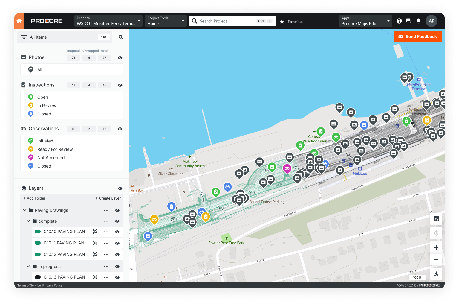
Geographic Information Systems (GIS) is on the rise.
GIS is advanced mapping software that’s used by organizations to track assets, visualize projects, power data analytics, and manage work.
New to GIS? Don’t worry. We’ve got you covered with our simple guide Intro to GIS: What It Is and How to Get Started.
But with great power comes great complexity. GIS has a reputation for being hard to use. After all, it has long required a degree or many hours of training to master, organizations hire GIS specialists to manage the software, and legacy systems were installed locally on desktop computers - not directly accessible in the field.
With Mobile GIS, this all changes. Teams can visualize GIS wherever their work takes them - collecting information on their mobile devices and accessing key asset data with little to no training.
So are organizations flocking to Mobile GIS? Not exactly.
Unfortunately, the reputation of Desktop GIS still haunts Mobile GIS. When “GIS” enters a conversation today, teams assume the system is overly complicated, entails clunky applications, and requires extensive training - which would doom field adoption.
This isn’t helped by the fact that many software providers sell a “Mobile GIS” that is little more than Desktop GIS crammed onto a smaller screen - a hard-to-use tool that field crews can’t make heads or tails of.
It doesn’t have to be this way.
We’ve created a guide reviewing the key traits of Mobile GIS (so you know what to look for) and review where this powerful software is being used today. Plus, get the ball rolling in your own organization with our tips on procurement and implementation.
What Makes an Effective Mobile GIS?
The definition is simple: GIS that’s accessible on a mobile device in the field.
However, many of the software providers claiming to sell a “Mobile GIS” don’t live up to their promise of connecting the office and the field. These providers take their existing GIS - which is powerful yet bulky - and simply package it up in a mobile app.
They assume mobility is the only feature that matters in Mobile GIS. This misses the point.
Let’s return to our earlier definition: GIS that’s accessible on a mobile device in the field. Field users aren’t GIS specialists, and they shouldn’t need to be. Ultimately, Mobile GIS should be so easy to use that field teams don’t even know it’s GIS.

6 Characteristics of Effective Mobile GIS
1. Mobile apps that actually work
2. Intuitive GIS visualization
3. Simple yet powerful data collection
4. A connected technology ecosystem
5. A whole lot more than GIS
6. Independence from your system of record
If you’d like to explore these 6 characteristics in more detail, we’ve put together a deep dive in our blog What is Mobile GIS? Key Traits and Uses.
Now that we’ve defined Mobile GIS, it’s important to address a key question before we get into the nitty gritty of implementation: Why does Mobile GIS matter in the first place?
Why Mobile GIS Matters: Example Use Cases

Remember, GIS data represents detailed information about the physical world.
The value of GIS may span many sectors, but it’s most critical to operations that cover large geographic areas: bridge construction, water quality sampling across a city, repair to a downed utility pole, assessment of miles of natural gas pipeline, and much, much more.
This is where Mobile GIS comes in. In each of the examples we listed, field teams are out in the real world completing inspections, accessing asset information, and documenting work.
The field needs easy-to-use GIS that works wherever their assignment takes them.
Let’s take a look at a few representative use cases.
Utilities (Natural Gas, Electric, & Water)

GIS is common at most medium to large utilities because their business is the built world.
Look out your window and you’ll likely see power lines, sewer grates, or a natural gas meter - signs of a complex network of infrastructure that keeps your neighborhood alive.
Utilities need extensive field operations to monitor and maintain these services, and Mobile GIS is playing an increasingly important role in this work.
We’ll narrow our focus to four key programs.

1. Inspecting natural gas lines & preventing explosions
Natural gas lines supply millions of homes with critical energy. It’s a priority for these utilities to avoid natural gas explosions - a risk posed by “cross bores.”
Cross bores occur when a natural gas line is unknowingly drilled through existing underground infrastructure. For instance, a natural gas line leading to a home could be drilled through a sewer pipe. If a field worker cleared out the sewer pipe because of a blockage, they’d hit the gas line and potentially cause an explosion.
This is a direct threat to public safety: There have been 18 known cross-bore-related explosions on record.
Utilities are tasked with inspecting miles upon miles of gas lines, and coordinating the replacement of any identified cross bores - a massive endeavor.
Mobile GIS can expedite these inspections - and ultimately shorten the timelines of these programs - by equipping a field worker with the situational awareness and data collection tools they need in the palm of their hand.
Traditionally, these inspections were completed on paper. A field crew would arrive at an address, run a camera down a sewer line looking for cross bores, spray paint lines on the road to indicate the location of pipes, and document everything on paper cards.
Unfortunately, this process was slow, data fell between the cracks, and after spending hours manually inputting this information into a GIS in the office, utilities often couldn’t trust the imprecise and patchy records.
Today, a field worker can use their phone’s GPS or a handheld data collector to record the locations of everything they find. Not only does this improve accuracy, but it’s instantly available to the office, which can jumpstart the replacement process if a cross bore is found.
Then, an installation crew can arrive on scene, see the location of relevant underground pipes, and get to work fast - without taking out a walk-wheel and spray paint, and re-doing all of their colleagues’ location work.
In short, Mobile GIS streamlines work that keeps communities safe. We see the same value in Mobile GIS with electric utilities who are facing mounting threats from extreme weather.
Interested in the role of Mobile GIS in preventing natural gas explosions? Check out Why Mobile GIS is Critical in Cross Bore Detection and Mitigation.

2. Protecting power lines & mitigating wildfire risk
We’ve all experienced it. The lights go out, you try flipping the switch, and nothing happens. There’s been a power outage.
While losing power is a common experience, most people are unfamiliar with the actual power restoration process and what utilities do to prevent outages in the first place.
For instance, utilities maintain vegetation management programs, where they monitor the foliage near power lines and remove any dead, dying, or overgrown vegetation that poses a threat. This vegetation could fall on the line in the event of a storm or even start a wildfire during dry conditions.
The only problem: Utilities maintain thousands of miles of distribution and transmission lines.
To manage these inspections efficiently, utilities need two things: 1) Easy-to-use data collection tools and situational awareness that teams can leverage in the field, and 2) a mixed dataset that overlays satellite imagery, drone orthomosaics, LiDAR, and other innovative technologies to monitor large geographic areas.
Mobile GIS can do both by dissolving siloes, integrating intelligent geospatial data, and connecting field devices.
See how in Unearth’s blog How Mobile GIS Streamlines Vegetation Management.

3. Emergency response & power restoration
Of course, utilities are not only concerned with prevention - they must respond to emergencies as well.
Here, too, Mobile GIS provides value.
For example, a utility must assess the damage to its infrastructure following a tropical storm or wildfire to assign crews, organize resources, and understand when it’s safe to turn the power back on.
The faster a utility can complete this damage assessment, the faster it can get the power restored. This can be a matter of life and death for customers who depend on power for medical devices or temperature control.
Instead of relying on paper or radios while driving through neighborhoods, assessors can use Mobile GIS to quickly photograph downed lines, blocked roads, and other damage points - pinning them to a real-time map. This method is faster and more accurate, and avoids duplicate data entry.
Ultimately, a utility’s command center can trade whiteboards, crowded email chains, and the endless buzz of text messages for Mobile GIS, a single source of field truth and communication on an easily digestible map.
Explore the challenge of extreme weather and the role that Mobile GIS has to play in The Urgent Case for Mobile GIS in Utility Storm Response.

4. Replacing water lines & limiting lead exposure
We’ve covered how electric and natural gas utilities are using Mobile GIS to streamline field work and protect the communities they serve - but there’s another important type of infrastructure that’s top of mind in the news: water.
Water arrives at homes through service lines that connect to the water main running down a neighborhood street. With the crisis in Flint, Michigan, there’s a spotlight on the fact that there’s an estimated 6 to 10 million service lines that are made of lead.
There’s no safe lead level for children, and yet millions of Americans are drinking water contaminated with it.
Recent regulation, funding, and initiatives are designed to get this lead out of communities. But first, water systems need to figure out exactly where all of these lead services lines are located.
Since many lead lines are located on the customer side of the property, water systems don’t have records of them. The first step in getting the lead out of communities is building an inventory of all lead service lines. This effort requires boots on the ground.
Mobile GIS provides the perfect platform to build an inventory considering the number of stakeholders involved. Water systems will rely on field teams, office employees, contractors, non-profit organizations, other municipal programs, and more to collect the data they need. It’s a community effort. And Mobile GIS is defined by its accessibility.
Water systems using Mobile GIS can add stakeholders from across the clean water ecosystem to knock on doors, test pipe material in customer homes, dig up service lines, and sort through historical records - all of this information centralized in one intuitive place.
For more on Mobile GIS’s role in clean water, check out Lead Service Line Inventories: Everything You Need to Know.

Construction
While GIS is a critical technology for asset owners like utilities, it’s still gaining traction in construction. However, a recent report suggests it’s on the rise in the industry, and contractors will lose their competitive edge without the technology.
Notably, 40% of the contractors surveyed used GIS in more than half of their projects to collect data on site and to provide digital asset information at the end of construction.
By turning over GIS data, contractors make it easy for owners to import asset information into their system of record and access key data during ongoing operations and maintenance.
But it’s not just about project handover.
Mobile GIS provides a more intuitive way to visualize a construction project, especially when it spans across a large area. Instead of storing data in folders, lists, emails, and texts, contractors can see everything on a real-time map. At the end of the day, it just makes more sense to look at a map when you’re navigating the real world.
It’s true many contractors turn to Google Earth to map project data, but Google Earth isn’t built with construction in mind and entails clunky workflows. We’ve found there aren’t many tools actually designed for large infrastructure projects - a perfect opportunity for Mobile GIS.
In a recent report, we identified 5 ways digital maps can save contractors time on their projects:
- Progress tracking
- Project updates
- Digital as-builts
- Advanced work packaging
- Dispute resolution
Despite these benefits, contractors often dismiss GIS as too complex, so there’s significant potential for Mobile GIS to get traction with teams who’d never consider adopting a complicated GIS system.
In the construction industry? In our blogs, we’ve also explored how construction mapping software increases profit margins and examined three ways Mobile GIS simplifies construction project management.

Mobile GIS revolutionizes field data collection across sectors
We’ve discussed the value of Mobile GIS to utilities, emergency response operations, and construction, but there are truly endless applications for the technology. The need for simple yet powerful field data collection tools spans entire sectors.
A data specialist at Unearth illustrated this point recently in an interview reflecting on her career before joining our team.
At one point, she worked as a biological technician for the National Park Service at Mt. Rainier, and hiked to remote lakes, paddled out in a raft, and took environmental measurements with pen and paper. She’d then carry this paper to headquarters and someone would manually input everything into online records.
There’s a consistent theme across construction, utilities, and even the National Park Service: manual data collection and transfer.
Whatever your career, it’s likely there’s a program or workflow that could benefit from Mobile GIS. And with that in mind, let’s take a closer look at the immediate benefits and implementation of Mobile GIS in the field.
Mobile GIS in Action: Case Studies
As anyone knows who’s procured software, it’s one thing how a tool’s advertised, and it’s another thing entirely how it gets implemented and works in reality.
We’ve seen this discrepancy firsthand in conversations with contractors, and we’ve heard the horror stories. Contractors see potential in a technology but it fails to be adopted by their crews. And if it’s not adopted by crews, it’s a huge waste of resources.
For this reason, it’s important to know the “Mobile GIS” you’re getting will live up to its promises because the right Mobile GIS can transform the way the field works.

Rapid field adoption in Cincinnati, Ohio
Recently, Unearth visited Cincinnati to support crews who inspect and install natural gas pipes and see with our own eyes how Mobile GIS serves boots on the ground.
Unearth’s OnePlace software equips these field teams with the simple, mobile mapping tools they need to draw underground infrastructure, attach sewer camera video, and mark where work can safely take place.
At first, field adoption was a concern.
“We did meet some resistance,” Unearth’s Jay Smith said. “But after walking through a demo and short training in a truck with six guys, they were like kids in a candy store. They popped out of the truck and started logging and plotting points instantly. We saw users training users. That’s really cool.
“We had a guy who was 55 and had been doing his job for almost 20 years - and he was saying OnePlace is something we need to roll out to every crew, as soon as possible. That our software was a must-have - a sign of where the industry’s going.”
Unearth’s Gabby Shelley noted, “Initially, our crew leader was worried about it, and thought it was too big of an ask of her team. But by the end of our visit, she was like, ‘I want everyone to be using this - I want it rolled out immediately.’
“Despite claiming she didn’t know how to use her phone, she was teaching the whole crew in the field on how to use Unearth herself.”
This visit affirmed what we’ve seen in our other case studies: Software needs to be the easiest part of an infrastructure crew’s day, and this is possible with Mobile GIS.
If you’d like to explore exactly how OnePlace is supporting these crews in critical yet dangerous work, read our blog Cincinnati, Ohio: Equipping the Field with Mobile GIS.

Entry-level GIS for a non-specialist
It’s worth repeating: Field access is central to Mobile GIS. But it’s also important to remember that this accessibility applies to the office as well.
Many organizations are unable to hire GIS specialists or afford a robust Desktop GIS. They may simply need an easy way to manage information on a map.
This was the case for Cristina Varriale, a researcher at the Royal United Services Institute (RUSI), funded by the Canadian Government.
She used Unearth’s Mobile GIS to examine satellite imagery of a chemical complex in North Korea and pin imagery captured from North Korean propaganda.
Her goal: Assess whether chemical weapons were being created or stored at the site.
You can read her research paper or our blog A Bird’s Eye View: Unearthing North Korea’s Chemical Weapons to learn more.
Varriale didn’t need many complex features to perform this analysis - she simply needed an easy way to geolocate data, make annotations against satellite imagery, and share her map with experts in the field.
Mobile GIS checked all her boxes - even though mobility wasn’t one of her qualifications. In the end, it all came down to the tools and ease of use.
Whether you’re a field crew inspecting sewer pipes in the suburbs or an academic analyzing geopolitics, Mobile GIS might be for you. Interested? It’s not hard to get started.
6 Steps to Mobile GIS Implementation
We’ve identified six key steps to successful Mobile GIS implementation through our experience working with utilities, construction companies, and other organizations.

1. Identify key stakeholders within your organization
Successful implementation depends on buy-in from project managers, field personnel, and GIS analysts. If you have a GIS team, it’s crucial you have their support.
It’s a story as old as time: An organization considers a Mobile GIS for their field teams, but GIS specialists offer to build an in-house solution instead. There are limits to this approach, however.
In-house software is expensive to build and doesn’t benefit from the insights that a software company gleans from its customers. Plus, organizations rarely estimate the resources it will require to maintain the in-house software, and miss out on key innovations over time.
GIS specialists may also dismiss the need for a Mobile GIS because they already have a cloud-based system in place. In this event, it’s important to understand the limitations of GIS when it’s not designed with the field in mind.
You can reassure your GIS colleagues that Mobile GIS won’t replace an organization’s back-office system of record. In fact, Mobile GIS is more effective when it’s separate from the system of record.
2. Lay out your current data collection process
This step provides the hard data about the value of investing in Mobile GIS.
Map out your organization's process for collecting, managing, and analyzing GIS data. Pay close attention to personnel needs, necessary software and hardware, average time spent, and total cost per step.
With this information, you can determine potential savings per project and per annum.
3. Research and evaluate Mobile GIS software providers
Again, many organizations make the mistake of trying to build an in-house GIS solution.
But it’s equally important that you don’t settle for a “Mobile GIS” in name only. Look for product videos so you can see the software in action.
You need the real deal if you want to ensure field adoption and efficiency gains.
4. Reach out to your top three options
If you’re a larger organization, integrating your new Mobile GIS will be much easier if you choose a provider who offers a certain level of customization, onboarding, and specialized support.
And if you’re on a smaller team, it’s still worth reaching out to a provider for a demo to ensure the product will meet your needs and is actually accessible to a non-specialist.
Better yet, identify products that provide a free trial. There’s nothing better than exploring the software yourself.
5. Make a decision and get buy-in
Ideally, your vendor should be able to provide materials that present their product to your organization.
Make sure to start getting buy-in from the very beginning for this step to be successful. You need enthusiastic internal advocates to cross the finish line.
6. Roll it out
Work with your provider to create an implementation plan.
Your training needs will depend on the size of your organization: Some teams require in-person training while others may find a library of How-To videos sufficient.
For more on implementation, check out our blog How to Streamline Field Data Collection with Mobile GIS.
See Mobile GIS for yourself with a free trial of Unearth’s OnePlace
We’ve created a simple Mobile GIS built for anyone and any project called OnePlace.
We’ve also designed purpose-built workflows on the OnePlace for construction, utilities, telecom, oil & gas, and water.