Why is Mobile GIS critical to utility storm response?
A review of the last few years is revealing: responding to modern weather requires modern technology.
New to Mobile GIS? Check out Unearth's introductory guide.
A once-in-a-decade winter storm in Texas. A historic wildfire spreading in California. A category four hurricane slamming Louisiana. Billion-dollar hail storms, tornadoes, and flooding.
2020 set a record for billion-dollar disasters, but 2021 has also proved to be an unprecedented time for extreme weather. But this isn’t the only challenge utilities face.
In 2021, the Biden Administration highlighted the urgency of aging infrastructure, mounting cyber attacks, and green energy. Add the rise of smart tech and distributed energy resources (DERs) and it becomes clear that utilities aren’t merely repairing or securing the grid - they’re revolutionizing it.
Utilities are at an inflection point, but grid modernization doesn’t need to be paralyzing. Technological innovation in one area - like storm response - reduces risk and lowers costs, freeing budget for other upgrades to the grid.
21st century weather demands modern tools for clear communication, data sharing, work management, and collaboration among diverse stakeholders. Uniquely positioned to innovate in storm response, utilities should seek to consolidate and streamline field-to-office communication.
The goal must be a dynamic, secure, and interoperable Mobile GIS that reduces expense, mitigates regulatory risk, and keeps communities safe.
Extreme Weather: Myriad Risks and Complex Logistics
Joyce Msuya, the Deputy Executive Director of the U.N. Environment Programme, describes extreme weather as the “new normal.”
Remarkably, the U.S. has endured an average of 15 billion-dollar weather and climate disasters each year since 2015.
With catastrophic flooding, storms, freezes, and wildfires, major utilities - like PG&E in California - are planning multi-billion-dollar projects to prepare for extreme weather and avoid regulatory action.
In this, storm response should be a top priority.
The immense logistical and technological challenges in responding to storms along with the significant regulatory and reputational risks of prolonged outages are reason enough.
Tropical Storm Isaias - which caused outages along the East Coast in 2020 - aptly illustrates the challenges and risks in storm response.

Downed power lines, fines, and profit reductions after Tropical Storm Isaias
After Isaias, utilities in New York alone were fined over $110 million for failing to follow their emergency response plans.
Likewise, Connecticut’s utility commission fined two utilities around $30 million in total civil penalties and imposed profit reductions worth millions of dollars per year.
Utilities risk severe penalties because a storm and power outage pose serious threats to communities:
- Vulnerable customers depend on electricity to survive, especially those with medical devices
- Downed power lines threaten pedestrians and complicate road clearing necessary for first responder vehicles
- Critical facilities - like hospitals - can’t or shouldn’t remain on generators
- Citizens lose access to work and wages, and companies lose business or experience delays in production
- Food, medicine, and other products are spoiled without refrigeration
Considering an outage isn’t merely an inconvenience - and weather will only become more extreme - states are pursuing stricter regulation.
In Connecticut, for instance, legislators held utilities accountable by passing a “Take Back the Grid Act.” House Bill 7006 requires utilities to reimburse customers for spoiled products and days without power, among other measures.
Regulatory action can even threaten a utility’s existence. After an initial investigation, New York state threatened to revoke utilities’ operating licenses.
Put simply, failures in storm response carry serious financial, reputational, regulatory, and business risks. However, mitigating these risks is complicated by the significant logistical and technological challenges in storm response.
Logistical and technological challenges in storm response
With Tropical Storm Isaias, utilities’ emergency response plan violations ranged from storm forecasting to managing their municipal liaison programs.
In the end, the logistical and technological challenges of effective storm response can be distilled to needing sufficient resources, accurate information, and clear communication.
According to state and municipal reports, utilities in New York and Connecticut struggled in many of these areas:
- Forecasting and classifying the storm
- Pre-staging adequate resources
- Developing accurate damage assessments and ETRs
- Communicating with customers and government stakeholders
- Managing their municipal liaison programs
- Collaborating in road clearing efforts
- Coordinating field crews
Storm response is formidable because a failure in one area has cascading effects.
An effective response, for example, hinges on an accurate and timely damage assessment, and this assessment relies on sufficient pre-staged resources, which in turn depend on an accurate forecast and functional storm level identification.
Likewise, poor field worker management hampers collaboration and communication with customers, telecom, municipalities, and other government stakeholders.
Innovation in field operations isn’t a cure-all for every challenge faced during Tropical Storm Isaias - like accurate storm forecasting and adequate pre-staging, for instance - but it’s relevant to many of these efforts.
Streamlining and consolidating field operations addresses two primary concerns undergirding recent penalties: effective coordination and collaboration in the field.

The importance of coordination and collaboration
To successfully respond to an emergency, utilities must coordinate multiple teams in the field, navigate many assets and asset owners, and collaborate with diverse stakeholders.
This is particularly true of storm response because a utility may be managing mutual aid crews and cooperating with multiple levels of government across multiple jurisdictions.
Responding to a downed power line may involve syncing an external line crew, a municipal liaison, first responders, municipal leaders and crews, and telecom.
Cooperation is necessary to efficiently record damage and asset owners, identify nearby crews and equipment, de-energize lines, make repairs, clear the road, re-energize lines, and ensure the system of record - across stakeholders - is up-to-date.
Otherwise, road clearing crews may be left waiting for hours to learn the status of downed lines or for utility field workers to arrive, as noted in reports from both New York and Connecticut.
A utility is coordinating information and resources from multiple sources during a dynamic situation that requires a timely response.
Any miscommunication or inefficiency endangers the public, and situational awareness is key to saving lives and avoiding regulatory action. With this in mind, utilities should prioritize innovating field operations.
Why Utilities Benefit from Transforming Emergency Response
Utilities are uniquely positioned to lead innovation
There are many private and public stakeholders in storm response, but utilities…
- Are first responders for many emergency response incidents and assume a “safety first” vision
- Maintain pre-existing relationships and coordination with municipal, state, and federal agencies
- Have access to critical infrastructure and customer data (e.g., medical hardship info, critical facility lists, etc.) and are major customer liaisons
- Possess the cyber experience necessary to manage critical infrastructure security and the resiliency of the networks that support it
- Operate in already complex regulatory environments
Considering their position, utilities should spearhead efforts to transform field operations in storm response. The risk and expense of doing otherwise is too great.

Innovation in field operations reduces risk and expense
Innovating in field operations within storm response drives value throughout an organization by…
- Cutting storm expense through optimized work and resource management; data collection and sharing; and FEMA documentation and regulatory compliance
- Minimizing regulatory risk by organizing more effective storm response on a secure, scalable platform
- Lowering long-term O&M expense by operationalizing new data streams for predictive infrastructure risk models
Instead of piling onto a list of new expenses, innovation in storm response can free existing budgets to modernize the grid.
Utilities must streamline operations and maximize existing resources because grid modernization will be an enormous undertaking.
Cybersecurity and renewable portfolio requirements aside, global organizations will need to invest more than $40 trillion in decades-old water, electric, and natural gas infrastructure between 2016 and 2040.
Much of the U.S. grid was built not long after WWII. With advancements in smart meters, DERs, and battery storage, tomorrow’s grid won’t resemble today’s.
To survive in the 21st century, utilities need to innovate.
How Mobile GIS Streamlines Field-to-Office Communication
Long before Tropical Storm Isaias, authorities recognized the necessity of innovation in storm response.
A 2016 Department of Energy report stressed the value of “a common operating picture” and challenges in communication, information sharing, and logistical coordination.
And as early as 2013, a GridWise Alliance report following Superstorm Sandy underscored the importance of “integrat[ing] new field intelligence processes, tools, and data to rapidly and accurately pinpoint outages and assess the condition of physical assets.”
Now more than ever, as extreme weather grows more severe and frequent, utilities must streamline and consolidate field operations.

Defining an effective Mobile GIS for multi-agency response
Utilities and their partners need a Mobile GIS optimized for coordination and collaboration, and characterized by the following:
1. Consolidated and interoperable
Establishing a single source of truth during an event is essential in storm response because the number of stakeholders involved is considerable.
Utilities need to consolidate storm response into a single interoperable Mobile GIS, where teams spanning different organizations and agencies can collaborate.
Collaborating With Mutual Aid, Telecom Companies, and Municipalities
In New York, when addressing downed wires and cables, poor coordination between utilities and telecom companies - as well as failure to leverage municipal crews and equipment - directly slowed municipal road clearing efforts.
FEMA and the NAPSG Foundation have both underscored the importance of data sharing and standardized resource management for improved mutual aid.
Utilities can foster effective cooperation between agencies through a data-agnostic field solution, which can interface with telecom, mutual aid, and neighboring utilities’ systems.
They may also consider granting partial access to their system - or even sharing the same platform - to consolidate onboarding, resource inventories, and incident management.
Alternatively, a multi-agency response could leverage a multi-agency platform.
Municipalities expressed interest in a “common web-based incident management system” to promote collaboration and visibility following Isaias, and one county legislator recommended a map-based app for “a more transparent way to track the location of crews.”
Municipalities also benefit from maps of the electrical grid and critical facilities - something not all had access to during Isaias. Likewise, a Connecticut official observed “the lack of a reliable system for emergency responders to receive accurate data” regarding outages.
With a single platform, agencies could share a real-time operating picture, partner in tracking teams and resources, and accelerate damage assessments, which would broaden a utility’s situational awareness and optimize their response.
2. Real-time and accurate
According to Public Power, communication in the field should be “as near real-time as possible,” and geographical and electrical system data issued to crews is more effective when accessible online through a tablet or smartphone.
Utilities need Mobile GIS because it’s cloud-based and mobile-friendly, and offers offline capabilities along with automatic syncing to promote real-time and accurate information.
Work Management
If teams rely only on radios, cell phones, paper maps, and whiteboards to coordinate mutual aid, manage incidents, and receive assignments, they must contact the command center to receive information and manually update their own records.
This involves more parties, slows the flow of information, may be affected by poor cell service, and increases the likelihood of human error and duplicate reports - field teams and the command center may end up with stale information during a dynamic emergency.
Real-time tracking of crew and equipment location along with fuel consumption and material use ensures visibility and efficient coordination and resource utilization.
With this situational awareness, utilities better understand where to direct crews and how to leverage municipal teams and equipment, and municipal road clearing efforts aren’t left to sit for hours, in the dark, waiting for support that never comes.
Documentation & Compliance
Additionally, maintaining a single real-time Mobile GIS - where stakeholders can view an incident, its history, and track current progress - ensures accuracy.
Accuracy is not only essential to a utility’s coordinated response but also the FEMA documentation of maintenance, damages, and resource use after the event.

3. Geospatial and intelligent
In the past, utilities depended on trucks, helicopters, municipal liaisons, first responders, and customers to report damage, outages, and blocked roads - which were then manually logged into a command center system.
Mobile GIS can empower field personnel to log this information directly on a map. It can also harness new data streams and opportunities for automation.
Data Collection
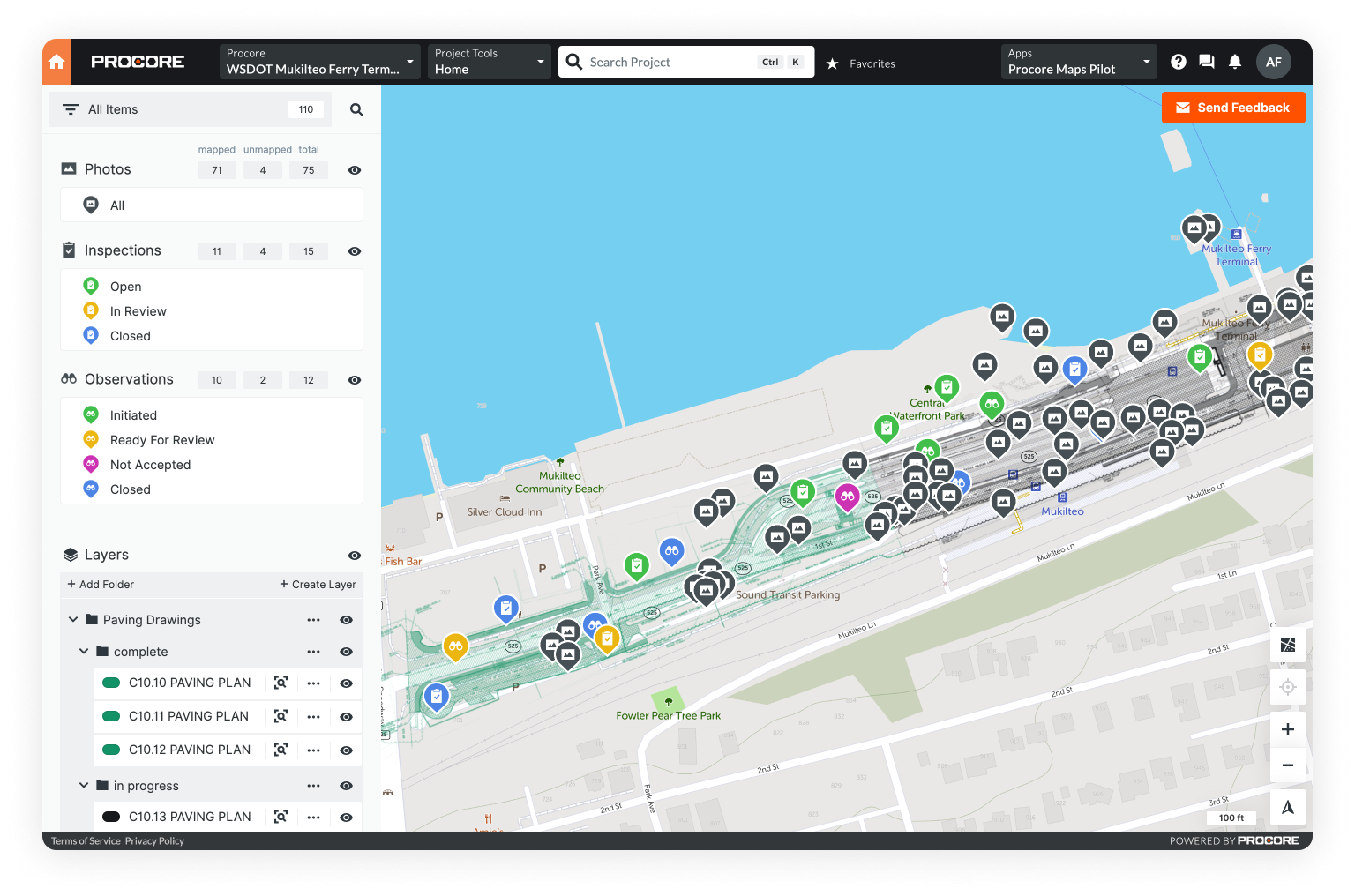
With Mobile GIS - a map-based platform - linemen can easily pin photos, videos, and other files to their real-world locations, geo-tagging and linking the data to specific assets. Utilities may even consider a customer-facing interface where volunteers and the public can also document damage in the field.
To Chris Mcintosh, an advisor in disaster preparedness, “Maps are the most powerful situational awareness medium out there.”
Transforming data collection can expedite damage assessments - and if field crews are equipped with satellite imagery, GPS, and a live map, their response will be more efficient.
Storms can damage structures, physical landmarks, and signage - making it difficult for field workers to navigate an unrecognizable environment. Even when this isn’t the case, mutual aid crews still need support navigating unfamiliar cities.
An intelligent field platform can also automate data gathering. Workers won’t need to wait for a phone call and then input data manually, which may be out-of-date by the time it reaches a municipal liaison anyways.
For example, field operations software can listen to automated feeds - e.g., social media, next generation 911, fire and police - and import the data into the app before automatically creating an incident and dispatching crews.
There’s also potential to better leverage smart meter data in creating outage and damage reports, as well as prioritizing repairs.
And within the map, users can deploy layers to precisely visualize workflows, sort and organize data, and verify or update reports

4. Scalable and user-friendly
Edison Electric Institute highlighted a significant challenge for utilities: scalability. A utility should be able to “run smoothly whether there are 5,000, 50,000, or 500,000 customer outages.”
Public Power describes scalability as “one of the most important qualities of an effective restoration,” stressing the challenges in managing a much larger workforce and incorporating mutual aid.
A Mobile GIS already goes a long way in enabling scalability by automating and streamlining data collection.
For instance, one critique of the storm response following Tropical Storm Isaias in Connecticut was “the manual process for logging blocked roads did not reasonably scale to the severity of [the storm].”
However, the platform must also be user-friendly to ensure rapid onboarding and empower workers in the field.
Onboarding
To “scale up” in response to a storm, a field operations platform shouldn’t require extensive training - the tools should be intuitive, easy to learn and use, and accessible on any mobile device.
This way, contractors and mutual aid crews can leverage the platform instead of relying on inefficient communication through radios, cell phones, or paper documentation.
Stress is another important concern for mutual aid crews, who are entering a disaster and unfamiliar setting, and a user-friendly platform can help mitigate this stress by improving their situational awareness.
Mobile GIS could even play a role in the onboarding itself - identifying housing, food, and other resources for incoming crews on the map.
Empowering Field Workers
In New York, municipal officials noted utility crews depended on a “centralized source” for assignments - a distant command center - and supervisors in the field weren’t empowered to direct these crews.
Restoration crews should have had “direct and constant access to individuals with the authority to re-energize parts of the utility’s grid.”
Utilities can provide this access to authority by providing every worker with a command center in the palm of their hand.
Field workers could be automatically notified of assignments within a mobile app, while supervisors could view incidents and assign crews - all in real time.
Decentralizing authority - while maintaining clear delegation and streamlined data sharing - powers scalability.

5. Secure and safe
The first death directly linked to a cyberattack occurred in September of 2020, after a ransomware attack on a local hospital in Germany delayed a woman’s treatment.
Cybercriminals haven’t yet interfered with storm response, but previous attacks - like those in Ukraine in 2015 and 2016, which caused blackouts in sub-zero temperatures - suggest hackers aren’t afraid to attack utilities or endanger human lives.
Hackers have a lot to be gained by threatening utilities - as the Colonial Pipeline shutdown and subsequent $4.4 million payment illustrate.
Like hospitals, storm response is a ripe target for cyberattack, meaning utilities need a Mobile GIS that is fully secure.
Authority & Access
Though it’s vital to empower crews to see data, enter reports, and receive assignments, this accessibility also introduces cyber risk.
Utilities must protect their systems from internal bad actors.
To ensure information security, utilities should establish different permissions, roles, and controls among workers, especially third party contractors and mutual aid. Ultimately, they should control who sees what and who’s able to modify different information.
Cyber risks notwithstanding, creating custom roles and permissions is a best practice for mitigating human error, ensuring efficient delegation, and making data actionable.
Cyber & Information Security
When utilities are procuring any new software, it’s essential to hold vendors to high standards - and rigorous security is particularly crucial for a storm response platform.
Fortunately, there are private and federal designations that can help a utility assess software security.
For example, a company may be SOC 2 Type 2 compliant, which indicates they’re routinely audited on their security standards created by the American Institute of CPAs (AICPA).
SaaS companies which store data in the cloud on Amazon Web Services (AWS) servers - or in a similarly secure location - provide an additional layer of assurance.
With the right controls in place, a Mobile GIS can be leveraged by diverse stakeholders without sacrificing security and safety.
Addressing looming cybersecurity risks while tackling significant technological and logistical challenges may seem insurmountable. But innovation in field operations empowers teams to overcome these hurdles.
Utilities are well-positioned to provide this Mobile GIS and reap the financial and regulatory benefits.
Modern Weather Requires Modern GIS
According to a 2021 report by the Intergovernmental Panel on Climate Change, global warming is driving more extreme heatwaves, precipitation, droughts, and cyclones.
The UN Secretary-General called this report a “code red for humanity.”
The future may be uncertain, as global leaders scramble to mitigate climate change, but utilities can certainly expect more extreme weather events.
The question is only how much worse they will get.
In light of this, utilities can anticipate weather that’ll require a regionalized response and involve more data, stakeholders, outages, and field crews.
Increasing electrification will also only make the grid more vital and complex.
Fundamentally, efficient coordination and collaboration will be more important than ever in the future - and utilities will need new tools like Mobile GIS to streamline operations.
With lives on the line, innovating field operations within storm response is a priority.
Discover the power of Mobile GIS
Start your a 30-day free trial of Unearth's OnePlace for Emergency Response.