GIS Software

Introduction to GIS software

There are two basic categories of GIS software: commercial and open-source.

Commercial GIS software involves a paid license of some kind, either through subscription or a one-time perpetual license. Open-source GIS software is free for anyone to use.

Within these broad categories, there are many individual software options: each with significant variation in terms of functionality, price point, and ease-of-use.

When choosing a GIS software, first decide between commerical and open-source.

Learn the basics of GIS with part one: What is GIS?

gis data depicted on a map

Commercial GIS software tends to have more capabilities and better support, but can be quite pricey.

Open-source software has the distinct advantage of being free, but often has less functionality.

Next, consider where, how, and by whom the platform will be used. The answers to those questions will help determine software type (desktop, online, or mobile) will be most effective.

In this chapter, we’ll cover the different types of GIS software, as well as the most popular commercial and open-source GIS platforms available.

I. Types of GIS (Advantages/Disadvantages)

II. Commercial GIS Software

III. Open-Source GIS Software

Implementing GIS is easier than you might think. Find out what software and hardware you need at our blog Intro to GIS: What It Is and How to Get Started.

Types of GIS software

GIS software comes in three main formats: desktop, online/cloud, and mobile.

Many platforms are only available in one format, while others allow for a combination.

For example, a legacy GIS software such as ESRI, offers both desktop and online options. However, each product must be purchased separately.

Below we’ll explore the advantages and disadvantages of between desktop, mobile, and online GIS.

Desktop GIS

Desktop GIS software is installed directly onto a desktop or laptop computer. The program will only run on that computer and all data is stored on a local hard drive.

In terms of functionality, desktop GIS tends to be more robust. For organizations doing geo-scientific research, complex spatial analysis, and 3D rendering - these platforms are an attractive option.

a laptop and desktop computer displaying Mobile GIS

Advantages of desktop GIS

  • Greater overall functionality
  • Runs without internet
  • Development tools for bespoke GIS app creation
  • Larger screen space
  • More processing power for handling large files and rendering complex scans

Disadvantages of desktop GIS

  • Data is siloed and difficult to transfer/share
  • Requires specialized personnel to operate
  • Licensing structures restrict usage
  • No data capture functionality
  • Often requires expensive hardware to run
  • Infrequent updates compared to online GIS
  • Significantly more expensive upfront

Online/cloud-based GIS

Online GIS is most frequently run on cloud servers: eliminating the need for installation and local data storage.

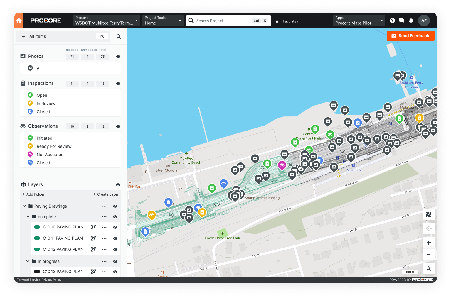
With cloud-based GIS platforms, users can make updates in real-time, access data from anywhere, and share information quickly.

Most online GIS platforms operate on a monthly or yearly subscription basis. This stands in contrast to desktop platforms, which are more expensive upfront, but only require a one-time payment.

a cloud connecting data to field teams

Advantages of online GIS

  • Access data from anywhere on a wider variety of devices
  • Transfer and share data in real-time
  • Use with little to no training
  • Potential for field data capture (when used on a mobile device)
  • Significantly lower upfront costs

Disadvantages of online GIS

  • Relies on an internet connection (though some platforms do have an offline mode)
  • Organizational concerns about data security
  • Less functionality in terms of spatial analysis and 3D rendering
  • Less developed knowledge and learning base
  • Cloud servers do occasionally experience down-time

Check out Part 5: Online GIS to learn more

Mobile

Mobile GIS is, in many ways, a subcategory of online GIS. Most mobile devices don’t have the processing power necessary to run a GIS software locally, and so rely on cloud-based mobile applications.

Some GIS softwares offer mobile functionality as a built-in feature, while others require additional purchase of a separate mobile program.

Theoretically, mobile GIS can run on any mobile device; however, device cross-functionality ultimately depends on which platform you choose.

a man using Mobile GIS on a mobile device

Advantages of mobile GIS

  • Enables data capture in the field
  • Access data from anywhere
  • Share updates in real-time
  • Increased communication between stakeholders
  • More practical for use in an emergency/disaster response scenario

Disadvantages of mobile GIS

  • Data sharing and transfer requires internet connection
  • Limited functionality compared to desktop or online platforms
  • Not all platforms are compatible with every mobile device
  • Limited screen space
  • May require a separate purchase (depending on the platform)

Commercial GIS softwares

Commercial GIS softwares require a subscription or a one-time perpetual license. They can be divided into two categories: desktop and online.

Desktop GIS platforms tend to have the broadest, most powerful feature suites.

Look to these programs for complex spatial analysis, 3D rendering, and advanced map making.

Keep in mind - with that advanced functionality, comes the steepest learning curve and highest price tag.

In this section, we cover five of the most popular desktop commercial GIS software options.

Each of the platforms below involves a one-time perpetual license fee and must be installed onto a specific computer.

Click any of the links below to jump to that platform.

esri logo

Name: ArcGIS Pro
Type: Desktop
Price: $700-$3800/year
Best for: Advanced map making, spatial analysis, 3D visualization
Mobile capable: Yes, with purchase of ArcGIS Online

Summary: ESRI’s ArcGIS Pro has long been the desktop GIS powerhouse. ArcGIS was released as a commercial product in the mid 1980’s; however, ESRI originated two decades earlier as a geospatial research institute. With separate products for online and desktop, an enterprise solution, and ArcGIS for Developers, the ArcGIS product suite is quite expansive.

Each ESRI product is sold separately from the base product. Most users start with the base product and then add functionality as needed. For users who require an advanced solution with robust geospatial functionality, ArcGIS Pro is one of the most comprehensive mapping and data analysis platforms on the market.

pitney bowes logo


Name:
MapInfo Pro
Type: Desktop
Price:
$2295-$4295/year
Best for:
Detailed mapping, data visualization, location analytics
Mobile capable:
No

Summary: MapInfo Pro has slowly grown in both functionality and popularity since its initial release in 1986. The product is focused on location intelligence: helping users to visualize and edit location-based data in order to analyze relationships and reveal trends. Practical examples of location intelligence include finding the best location for a business, or analyzing a geographic area to calculate insurance risk. Users report that MapInfo Pro is more straightforward when compared to other GIS software. It also has first-class support for cross-platform integration, syncing easily with popular CAD platforms.

hexagon geospatial logo

Name: GeoMedia
Type:
Desktop
Price:
Quote based
Best for:
Data visualization, sophisticated query and analysis, data validation
Mobile capable:
No

Summary: GeoMedia is owned by Hexagon GeoSpatial. It’s sold in the Power Portfolio product, which is part of the Producer Suite. The Producer Suite helps users gather, process, and analyze geospatial data. As the name implies, it’s a suite of products - one that includes GIS, remote sensing, and photogrammetry solutions.

Data management is where GeoMedia truly shines: offering advanced data management and visualization functionality. It can also connect directly to popular enterprise data servers, aggregating and analyzing all GIS data in unison. One especially unique feature is the data validation tools. Data validation is valuable because it checks all incoming data for accuracy before integrating it else. This saves users a step and adds significant value to the product as a whole.

general electric logo

Name: Smallworld
Type:
Desktop
Price:
Quote based
Best for:
Complex network management, including planning, building, operations, and maintenance
Mobile capable:
Yes, with purchase of Smallworld Web Solutions

Summary: Smallworld is a suite of products owned by General Electric (GE) and intended for telecommunications, electric, gas, and water utilities. The base platform is called Smallworld Core and provides functionality for basic business solutions. For more specialized industry-specific work, add-on products are generally required. One advantage of Smallworld is its scalable native database, which can handle large networks while maintaining a high-degree of detailed connectivity. Moreover, built-in quality assurance tools ensure that all network data is consistent throughout the entire organization.

bentley logo

Name: OpenCities Map
Type: Desktop
Price: Not available online
Best for: Data management for organizations that map, plan, design, build, and operate operations, and maintenance
Mobile capable: Yes, with download of Bentley Map Mobile

Summary: OpenCities Map is a combination of CAD and GIS. It excels at intelligent geospatial object creation, spatial analysis, and 3D rendering. It’s also the only option on this list that’s intrinsically 3D. Though it can create, manage, and share 2D information, the built-in 3D functionality is where OpenCities really shines. It also features seamless support for leading spatial databases and includes tools for creating custom GIS applications.

Open-source GIS softwares

All the platforms below are open-source, meaning that anyone can download them for free. That alone makes them an attractive option for many.

The tradeoff is that functionality is not always comparable to commercial platforms. There’s also little to no training resources or technical support.

Even so, commercial GIS software can be quite expensive, so for individuals and organizations on a budget - open source is often the way to go.

qgis logo

Name: QGIS
Type:
Desktop
Mobile capable:
No
Best for:
A free, functionally comparable alternative to ArcGIS

Summary: QGIS is one of the few open-source platforms that’s effectively comparable to ArcGIS. Use it to visualize and analyze geospatial data, as well as to create, edit, and print data-driven maps. Though ArcGIS wins in terms of overall functionality, there are a few ways in which QGIS has ArcGIS beat. QGIS offers unparalleled support for different GIS data types, consuming over 70 different file formats without issue. Moreover, there are no license limits on available tools. Every GIS tool in the QGIS toolbox is available to all users for free.

gvsig logo

Name: gVSIG
Type:
Desktop
Mobile capable:
Yes, with Android app
Best for:
3D visualization and mobile data collection

Summary: gvSIG was created as an alternative to pricey commercial GIS software. Similar to most platforms on this list, it can accomplish most traditional GIS mapping and data management tasks. Where gVSIG really shines is its 3D visualization and rendering functionality, far surpassing that of QGIS. Unlike most open-source GIS mapping software, gVSIG can support field data collection.

Featuring a native Android app that can be used on Android phones or tablets, gVSIG makes it easy to collect data within the platform. gVSIG also offers a plugin called NavTable, which allows user to navigate visually between GIS data sets. When you select a table in your data set, that same table highlights automatically within the map-based visualization.

saga gis logo

Name: SAGA GIS
Type: Desktop
Mobile capable: No
Best for: High level physical geo-scientific applications, including environmental modeling and terrain analysis

Summary: Originally created as a tool for terrain analysis, SAGA GIS has since grown into a comprehensive GIS system. It excels at environmental modeling, terrain analysis, and other geo-scientific tasks. With lackluster line and point tool sets, it reportedly falls flat in terms of cartographic functionality. However, the raster processing and 3D rendering, both of which are fairly rare in an open-source GIS, are top-notch.

grassgis logo

Name: GRASS GIS
Type:
Desktop
Mobile capable:
No
Best for:
Academic projects, land management, and environmental planning

Summary: GRASS GIS is widely celebrated and used by the academic community. With extensive documentation and an open-source code base, this platform can be tailored to the needs of each specific project. With over 350 different digital tools, GRASS GIS excels at raster and vector manipulation. This toolkit is actually so advanced that other open-source platforms have adopted it into their own codebase.

GRASS GIS does have 3D rendering capabilities, though they are less advanced than other platforms on this list. The primary issues with this platform are the unintuitive user interface and poorly engineered cartography tools. Though it excels at data analysis, it is not recommended for mapping.

whitebox gis logo

Name: Whitebox GAT
Type: Desktop
Mobile capable:
No
Best for:
LiDAR conversion and hydrology projects

Summary: Released in 2009, Whitebox GAT is still relatively unknown in the world of GIS. Though it doesn’t have all the same cartography and processing functions as other GIS software applications, it is still fairly advanced. LiDAR conversion, such as LAS to Shapefile, is where the platform really excels. Though ArcGIS does have this functionality, it’s clunky, inconsistent, and difficult to use. With frequent updates, extremely fast processing speeds, and a similar user experience to ArcGIS, Whitebox GAT is considered an up and comer in the world of open-source GIS.

Conclusion

Desktop GIS has been around for decades. As such it a variety of options in terms of functionality and price point.

Though it does have a fairly steep learning curve, for complex data analysis and visualization it really can’t be beat.

In the next section, we’ll explore online GIS.

Online GIS tends to be simpler, easy to use, faster to implement, and significantly less expensive upfront. It also enables field data collection and fast data sharing.

This where software like Unearth's platform, OnePlace, shines.

Learn more in the next section.

a laptop, map cloud, and mobile device
Learn more about Online GIS in the next section