What is GIS?

Introduction

What is GIS?

GIS stands for geographic information system.

As a theoretical concept, GIS is the intersection of data and location. As a real-world application:

GIS software organizes, analyzes, and displays data in relation to location.

Used throughout a range of industries, there are hundreds of examples of GIS in everyday life.

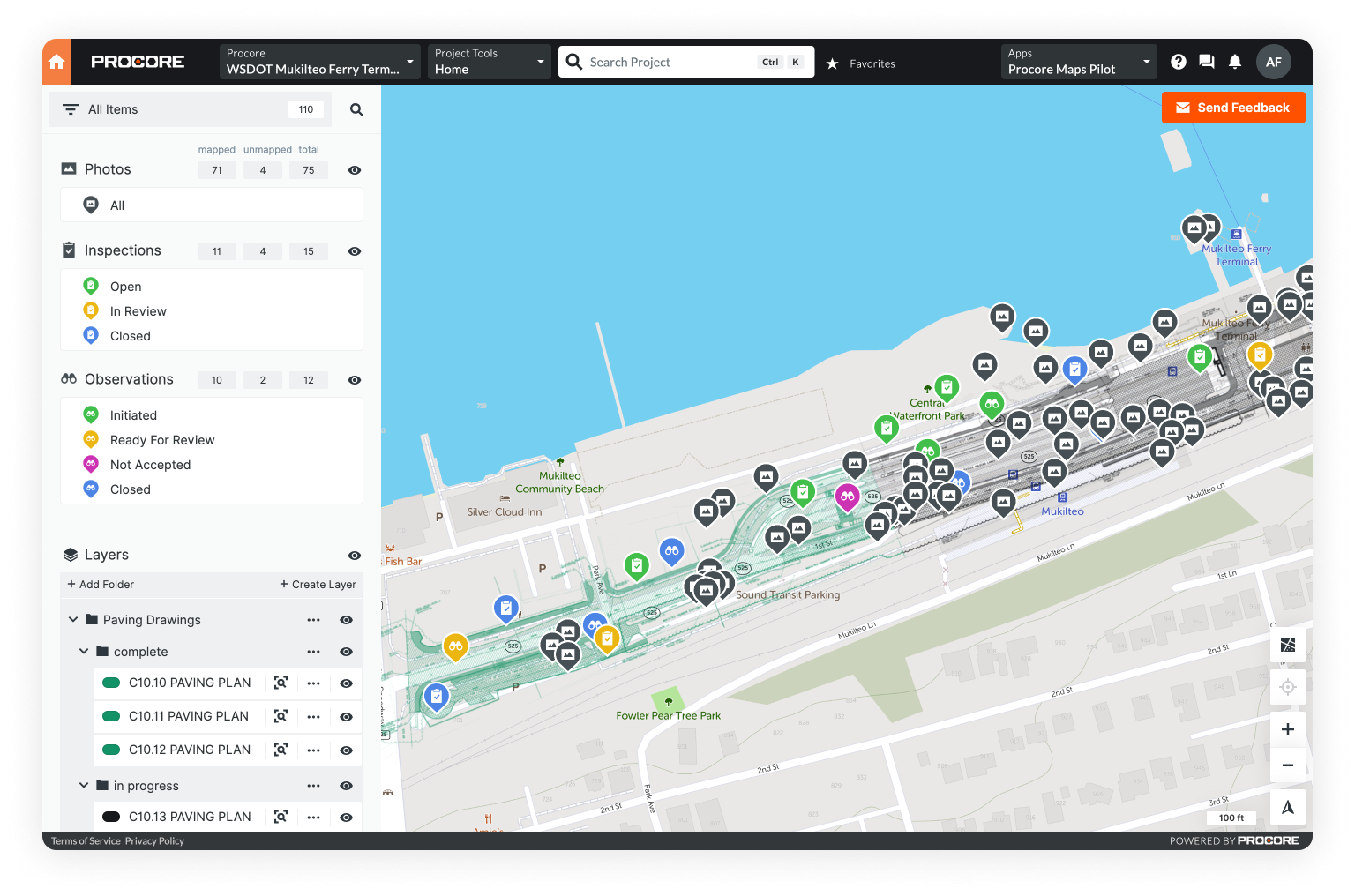
GIS data on a map

Because GIS is such a massive category, it's important to remember the following:

  • GIS data is always related to a location
  • Different organizations define and use GIS differently
  • Mapping software is a huge category and no two platforms are exactly the same

In this first chapter, we'll answer some basic questions about GIS.

Click any of the links below to jump there directly.

I. How does GIS work?

II. What can you do with GIS?

III. The History of GIS

IV. What are the components of GIS?

Short on time? Take a quick tour of GIS fundamentals in our blog Intro to GIS: What It Is and How to Get Started.

How does GIS work?

Picture a simple street map.

This map has the name, location, and intersection points for every street in a given area.

Now, you need to find a specific building. That’s simple. Add buildings - both homes and businesses - on either side of each street.

But what’s under the buildings? Add underground utilities - like gas lines and sewer pipes. Above? Power lines and telecom cables.

Suddenly, your simple map is much more complicated.

Add another variable, like vegetation data, and your map is now an unusable mess.

GIS maps let you display location-based data in layers.

Everything you added to your map - buildings, underground utilities, power lines, vegetation - can all be added as layers of location-based data.

The problem is that two-dimensional paper maps can only display a limited number of data sets before becoming disorganized and ineffective.

GIS was invented to solve this problem.

In the next section, we’ll explore examples of how GIS is used in everyday life.

a GIS layer with buildings dataa GIS layer with street dataa GIS layer with vegetation datacombined GIS data with multiple layers

What can you do with GIS?

GIS for simple mapping

Map making is far and away the most common use for GIS software. In fact, GIS was born from the desire to create maps that could handle large quantities of complex data more effectively.

GIS and mapping are so deeply intertwined, it's almost impossible to consider one without the other.

Think back to the map in the first section: the one with the streets, buildings, utilities, power lines, and vegetation.

With GIS, you can visualize all that data in one interactive map. Simply create a digital layer for each data set and then overlay those layers on the original street map.

View each layer independently or in tandem, in order to explore and analyze the relationships between each.

Visualizing data with GIS mapping allows you to:

  • Track as-built progress over time
  • Analyze spatial relationships
  • Manage tasks, projects and teams
  • Identify areas of highest risk
  • Chart transportation routes
  • Compare natural features with human activity

Though mapping is the most common use for GIS, these maps are also the foundation for a variety of other tasks: data management, asset management, change detection, etc.

Data management with GIS

From spreadsheets to photographs, satellite imagery to project tasks - GIS is an excellent tool for organizing, analyzing, and sharing location-based data.

GIS can be used to manage almost any data type:

  • Spreadsheets
  • Photographs
  • Videos
  • Topographic maps
  • Satellite and aerial imagery
  • Remote sensor data
  • Blueprints and plans
Location-based data requires a visual solution.
a digital map of a city representing GISa city visualized on a digital GIS map

Consider a sewer pipeline system.

There are over 2.5 million miles of pipeline in the United States. Imagine all that data in a spreadsheet: lengthy lists of addresses, asset IDs, and notes.

It would be completely unmanageable and near impossible to use. That data - the addresses and IDs - mean little without visual representation.

Most legacy GIS systems are excellent at managing data, but fall short with field data capture. As the industry has changed, some online mapping tools have started to offer this vital feature.

GIS for asset management

Physical assets tend to be geographically dispersed. Moreover, each one has its own history, specifications, and maintenance schedule.

This combination of data and location makes GIS the perfect tool for effective asset management.

GIS helps organize data, inform operational decisions, and reduce costs.

With GIS you can:

  • Track asset location
  • Create accurate records
  • Maintain an up-to-date asset inventory
  • Estimate asset lifecycle
  • Predict risk of asset breakdown
  • Build a data-driven preventative maintenance schedule

Physical assets are a varied category that spans a large range of industries. We'll go over a few of the most common below.

an aerial view of several structures

Fixed assets

Fixed assets have long life cycles and cannot be quickly converted into cash. Common examples include property, buildings, and equipment. To be a fixed asset, it must be possible to assess a value: meaning that intangible assets are not considered fixed.

an aerial view of a construction site

Infrastructure assets

Infrastructure assets are the basic physical structures - roads, bridges, electric grids - required for a functioning society. Infrastructure asset management focuses on maintaining, upgrading, and replacing these assets in order to improve quality and extend overall service life.

an aerial view of a public park

Public assets

Public assets are similar to infrastructure assets, but also include schools, parks, airports, and other common areas. Though the primary goal is to extend service life, there is also a focus on improving the community and optimizing use of public funds.

infrastructure GIS data

GIS for change detection

Change detection tracks how an asset or area has changed over time. Though you can track change through a spreadsheet or other linear workflow, these methods are not efficient.

GIS is the most effective way to visually track change across large areas, over long periods of time.

Methods for tracking change include:

  • Layering a progression of aerial surveys
  • Layering topographic maps
  • Overlaying blueprints on aerial surveys
  • Geo-tagged photo documentation
  • Simple task management

Change detection tracks how an asset or area has changed over time. Though you can track change through a spreadsheet or other linear workflow, these methods are not efficient.

The ability to track change over time, though fairly simple, is incredibly useful for most physical industries.

In construction, you can monitor project progress.

In forestry, you can track the interaction between human activity and the natural world.

In urban planning, you can track whether the identity of a physical asset has changed i.e. if a building that was a restaurant is now a pet store

Urban and regional planning with GIS

Urban planning is the process of designing and deciding land use in cities and municipalities.

From transportation, to communication, to distribution, urban planning is multi-faceted and can be quite complex.

Modern GIS is especially useful for cities experiencing rapid growth.

As a city grows, so do the infrastructure demands. Energy grids, sewer systems, pipelines, and roads, must all be planned and built in way that is both sustainable and scalable.

Urban planners can use GIS to compile all infrastructure data onto a map. With that map they can track current growth, monitor the health of existing infrastructure, and create a scalable plan for the future.

a map of rio grande del norte national monument on an ipad

Emergency and disaster management

One of the most relevant use cases for modern, eowing:

  • Defining the bounds of the affected area
  • Creating an inventory of destroyed property, damaged infrastructure, and missing people
  • Prioritizing action steps based on which areas were affected most
  • Creating comprehensive response and recovery plans

GIS is the perfect tool to complement one or all of these goals.

Modern GIS offers emergency responders a way to access and share location-based data quickly.

The history of GIS

GIS is not a new concept.

In fact, it's been around in various forms for decades.

ESRI, a pioneer in spatial analysis and creator of the first commercial GIS software, was started as a research institute in 1965.

In 1981, ESRI released a set of GIS software tools for commercial use. That platfrom, now called ArcGIS, has grown significantly: maintaining market dominance since it's initital release.

Legacy GIS platforms, like ESRI, offer massive suites of powerful features.

From oceanic basemaps, to 3D spatial analysis - legacy GIS programs offer a dizzying array of robust capabilities.

However, there is a catch.

a desktop computer displaying Mobile GIS software

Though powerful, these programs do have limitations.

Using a legacy GIS software effectively requires a degree and/or specialized training.

Moreover, most legacy GIS softwares rely on local servers to store data and offer little, if any, mobile functionality.

This limits usage to those who are in the office on a desktop computer: making data capture and sharing difficult.

All of this said, the GIS software landscape is changing.

The last decade has seen the emergence of GIS software that provides a simple, straightforward experience.

Modern GIS softwares, including MangoMaps, GIS Cloud, and Unearth help users reap the benefits of GIS with little to no experience.

While these programs don't offer the same heavyweight features, they do help users manage, organize, and share their location-based data without an advanced degree.

Moreover, most of these modern programs are cloud-based and mobile-friendly.

With cloud-based storage you can review updates in real time, share data faster, and connect all areas of an organization.

Mobile-friendly design lets users take GIS with them into the field: allowing for fast, efficient data capture within the GIS itself.

No matter what kind of GIS you use, there are certain components required in order to be successful.

an ipad and iphone displaying Mobile GIS software

What are the components of GIS?

Hardware

Hardware is the physical device on which a GIS platform is used: computer, laptop, tablet, cell phone, etc.

Most legacy GIS programs can only run on a desktop: requiring local servers. They generally can’t be used on mobile devices.

In contrast, most online GIS platforms are cloud-based and mobile-friendly.

Software

GIS software is the digital tool that allows you to capture, organize, analyze, and store data. Though all GIS softwares are different, most provide the following functionality:

  • Location-based data management
  • Tools for data capture
  • Options for visualization

Some, but not all, also offer online/offline features.

the four components of GIS coming together

Data

Data is arguably the most significant component of any GIS system. - it's also the most varied. GIS data can come in the following formats:

  • Spreadsheets
  • Satellite imagery
  • Blueprints and plans
  • Topographic maps
  • Shapefiles
  • So much more!

Without data, GIS is little more than a simple map.

People

Users are a critical and often overlooked component of GIS.

Legacy GIS was built, and continues to be updated, as a product that can only be used by someone with years of training and experience. Organizations that use GIS frequently, generally hire an in-house GIS specialist.

On the other hand, most modern GIS platforms were built to be accessible: opening up the power of data to everyone.

Conclusion

By now it should be clear that GIS is an expansive topic that can be quite complex. That said, we’ve tried to make it simple.

If you take nothing else moving forward, remember this - GIS software is a way to manage location-based data.

Try out online GIS software for yourself and map the data you already have - spreadsheets, photos, and more - with a free trial of Unearth's OnePlace platform.

In the next chapter, we’ll cover GIS mapping.

Mapping is far and away the most common application for GIS software. In fact, GIS and mapping are so intertwined - it's difficult to consider one without the other.

four images depicting aerial, satellite, and parcel imagery
Learn more about GIS Mapping in the next section